3 miles to 1 inch by associated newspapers ltd. The maps pre-date road numbering so possibley is before 1920.
If anybody has any suggestions which area would most likely date the map I will put a photo of that area up.
For more info on the Atlas see Antique Books and Map collection , the latter suggests its circa 1930.
Thanks
Undated Road Atlas - Help to date Please (pre 1920?)
Moderator: Site Management Team
If you've got either before 1920 or after 1930 as potential date ranges, find Wembley and see if the stadium is there. That will date it to pre-23 or post-23.
Hard to think of things that were built back at that time.
Edit... scratch that. I read the scale wrong
Hard to think of things that were built back at that time.
Edit... scratch that. I read the scale wrong
Last edited by timbucks on Mon Mar 19, 2007 15:59, edited 1 time in total.
These 3 miles to 1" map books by Johnson of Edinburgh were produced in the 1930s through to the 1970s. The basic map pages retained the same artwork throughout but were updated in part (eg addition of new roads and motorways, deletion of closed railways).
I have a 1939 (no publication date shown but it has injunctions about early wartime security issues) and it also does not have road numbers, which Johnson only added postwar.
Try looking for ;
A580 East Lancs Road
A127 Southend Arterial
A406 North Circular
Possibly the London area (presumably across two pages) was most likely to change each edition.
-
Steven

- SABRE Maps Coordinator
- Posts: 19251
- Joined: Tue Feb 12, 2002 20:39
- Location: Wolverhampton, Staffordshire
- Contact:
AndWHBM wrote:Try looking for ;
A580 East Lancs Road
A127 Southend Arterial
A406 North Circular
A4123 Wolverhampton - Birmingham New Road - built in 1927.
Steven
Motorway Historian
Founder Member, SABRE ex-Presidents' Corner
Add your roads knowledge to the SABRE Wiki today!
Have you browsed SABRE Maps recently? Try getting involved!
Motorway Historian
Founder Member, SABRE ex-Presidents' Corner
Add your roads knowledge to the SABRE Wiki today!
Have you browsed SABRE Maps recently? Try getting involved!
-
FosseWay

- Assistant Site Manager
- Posts: 19717
- Joined: Thu Feb 23, 2006 22:26
- Location: Gothenburg, Sweden
Re: Undated Road Atlas - Help to date Please (pre 1920?)
Unfortunately, the absence of road numbers isn't a reliable guide to date of publication. Apart from the 'MoT' series of half-inch maps that were supposedly updated yearly to reflect the numbering, no OS 1 or half-inch maps carried road numbers until the 5th series (late 1930s). It wouldn't surprise me if other map makers were similarly lax.AAndy wrote:The maps pre-date road numbering so possibley is before 1920.
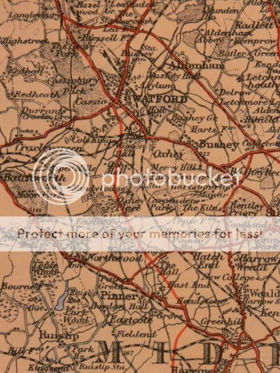
I would concur with other people who've suggested looking for specific high-profile roads built in the interwar era, to which I'd add the Kingston Bypass and the Watford Bypass. I don't know the year of construction of either, but the first printings of the OS Popular edition don't have them, so I'd guess they appeared in the mid-20s at the earliest.
Depending on the reliability/visibility of railway info, you could also look for extensions to the Tube to Cockfosters and, IIRC, the northern end of the Northern Line and the Watford Met bit of the Metropolitan, which I think were built in the early 30s.
Oh, and wasn't one of the tunnels under the Mersey built in the 30s?
Re: Undated Road Atlas - Help to date Please (pre 1920?)
W&AK Johnston Ltd maps did not include road numbers until after the war, I have a similarly undated version - with the added text :-AAndy wrote:3 miles to 1 inch by associated newspapers ltd. The maps pre-date road numbering so possibley is before 1920.
If anybody has any suggestions which area would most likely date the map I will put a photo of that area up.
For more info on the Atlas see Antique Books and Map collection , the latter suggests its circa 1930.
Thanks
"In order to comply with the control of Maps order 1940, Street Plans etc have been necessarily omitted from this edition"
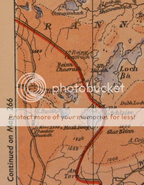
Another piece of road to look for is the A82 across Rannoch Moor - the current alignment being built in 1934.
Re: Undated Road Atlas - Help to date Please (pre 1920?)
The Edgware line was built in 1924, the High Barnet line in 1872 (transferred to LT in the 1940s)FosseWay wrote:AAndy wrote: the northern end of the Northern Line ......... which I think were built in the early 30s.
The Stanmore branch dates from 1932 though


-
Steven
- SABRE Maps Coordinator
- Posts: 19251
- Joined: Tue Feb 12, 2002 20:39
- Location: Wolverhampton, Staffordshire
- Contact:
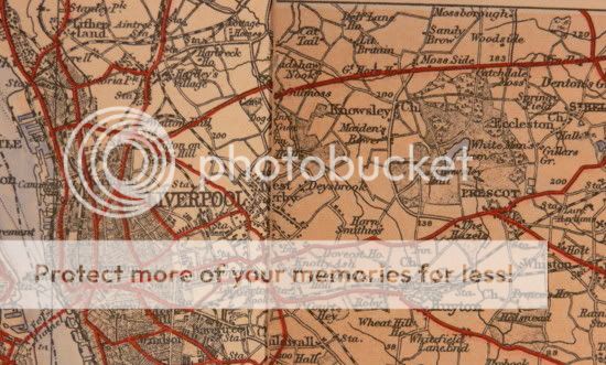
Post 1934 with the East Lancs Road there as large as life.AAndy wrote:Thanks for the help, must be post 1930....I think.
Steven
Motorway Historian
Founder Member, SABRE ex-Presidents' Corner
Add your roads knowledge to the SABRE Wiki today!
Have you browsed SABRE Maps recently? Try getting involved!
Motorway Historian
Founder Member, SABRE ex-Presidents' Corner
Add your roads knowledge to the SABRE Wiki today!
Have you browsed SABRE Maps recently? Try getting involved!
Does your edition have the town plans in the front - (they were removed during the war, then added back afterwards)AAndy wrote:I'm think it may quite a bit later than that Steven, with the east Lancs rd in the same type as most of the rest, yet the watford additions added.....probably 1940-1950?
edit: + the a mersy tunnel is there
(edit - mine has no index either)
The 1961 reprint although rather later does contain a list the publishing dates,
First Edition 1940, reprinted 1941 through 1947,
Second Edition 1948, reprinted 1949 through 1954,
Third Edition 1955, reprinted through 1956,
Fourth Edition 1957, reprinted 1958 through 1961.
Yes, mine has the street plans in the front ( & no index ) .aj444 wrote:
Does your edition have the town plans in the front - (they were removed during the war, then added back afterwards)
(edit - mine has no index either)
The 1961 reprint although rather later does contain a list the publishing dates,
First Edition 1940, reprinted 1941 through 1947,
Second Edition 1948, reprinted 1949 through 1954,
Third Edition 1955, reprinted through 1956,
Fourth Edition 1957, reprinted 1958 through 1961.
However, mine does not have the southern bypass built at Coventry in 1940....
so it could be between 1934 & 1940


Not exactly, I can tell you it didn't make 1932/33 edition of the RAC handbook but it did make the 1933/34 edition of the AA handbook. Sadly that's the best I can do - most of my early maps didn't bother to include Scotland - I guess it wasn't important enoughIan198 wrote:Haddington was bypassed in the 30s - anyone know the actual year?
The East Linton by-pass seems to be older....
BTW is that North Berwick law in your avatar?
Yes, it's an old photo looking west along what's now the A198 towards its junction with an unclassified road to East Linton. Taken here.aj444 wrote: BTW is that North Berwick law in your avatar?
-
Sunil_of_Yoxley

- Member
- Posts: 1770
- Joined: Mon Oct 06, 2003 12:14
- Location: Ilford, East London
- Contact:
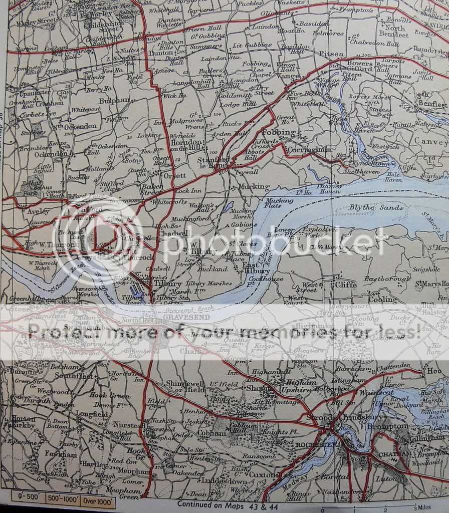
I have the opposite request! Could you please show the areas around Thurrock/Grays in Essex and also Stanford-le-Hope? Just want to see where the A13 ran back then! I know it doesn't date to 1922 which is what I really want. But just curious to know!
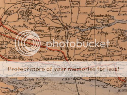
I note that on the Southend map you posted earlier in the thread the A13 runs straight through the town centre and also runs along Shoebury Road to the east (including the dog leg, still there today), and stops in Shoeburyness proper, rather than give up when it meets the B1016.
I note that on the Southend map you posted earlier in the thread the A13 runs straight through the town centre and also runs along Shoebury Road to the east (including the dog leg, still there today), and stops in Shoeburyness proper, rather than give up when it meets the B1016.
My London railway station photos on Wikimedia Commons
Here you go.......Sunil_of_Yoxley wrote:I have the opposite request! Could you please show the areas around Thurrock/Grays in Essex and also Stanford-le-Hope? Just want to see where the A13 ran back then! I know it doesn't date to 1922 which is what I really want. But just curious to know!
I note that on the Southend map you posted earlier in the thread the A13 runs straight through the town centre and also runs along Shoebury Road to the east (including the dog leg, still there today), and stops in Shoeburyness proper, rather than give up when it meets the B1016.