Chris5156 wrote: ↑Sun Jan 21, 2024 18:26
Really interesting - thank you!
freebrickproductions wrote: ↑Sat Jan 20, 2024 19:41With the Florida "kodachrome" shields, each route had its own color, though colors could be repeated between routes. The colors were also picked to try and avoid having two routes of the same color meet, though US 27 and US 192, both of which used green shields, did eventually meet due to an extension of one of them. The idea behind them was to help aid in motorist navigation. Auxiliary US Routes, like Business and Alternate routes, had the colors of the shields inverted, so that the backgrounds and text on the shields were of the route's assigned color, and the shield itself (and the bannered text above) was white.
I rather like this idea - you can communicate something extra with colour, without taking away anything from the symbols or text. It's quite clever. But I can also see that it's a nightmare for standardisation.
You're welcome! And yeah, especially since it wasn't standardized across the entire US, so drivers from outside of Florida may not have been as familiar with how the colors worked, along with the fact that the colors could mean different things in different states. Not to mention, with the green highway shields, you'd have to represent those with a white outline on a guide sign, similar to what California does with their green miner's spade state route shields.
Another issue is that, as I understand it, the other colors can fade faster than black, which I've heard cited as a reason by other local roadgeeks for why ALDOT appears to have stopped* installing new Appalachian Development Corridor shields.
(*It's entirely possible ALDOT had just simply ordered a batch of more-generic shields through a contractor, and are working through those as replacements.)
Anyways, I was able to dig-up my photos of the other "kodachrome" shields I've documented, so here they are, though I have no idea if any are still around and I know some are very much long-gone. To start with, we have this post in Panama City, FL, which has sadly since been removed. I think this may have originally been done by Panama City rather than FDOT, as this was located on a side street and the signs (and shields) were rather small. It did feature the last known "kodachrome" US 231 shield in Florida though, along with a "kodachrome" US 98 Business shield posted below it, though I didn't realize the latter was one until more recently. I took these photos back in 2016, and I believe this post had sadly disappeared by the time I returned in 2018.
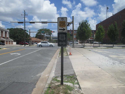 Old US 231 Shield
 by
freebrickproductions, on Flickr
 Old US 231 Shield
 by
freebrickproductions, on Flickr
And here's another "kodachrome" survivor from 2016 that I know is long-gone. This one was in Sneads, FL, and I have no idea if it was a casualty of Hurricane Michael or not.
 Old US 90 Shield
 by
freebrickproductions, on Flickr
 Old US 90 Shield
 by
freebrickproductions, on Flickr
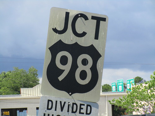
This next one was one of the surprisingly several "kodachrome" US 98 shields that was left along the "forgotten coast" of the Florida Panhandle at the time, with this one being located in Port St. Joe, FL:
 Old US 98 Shield
 by
freebrickproductions, on Flickr
 Old US 98 Shield
 by
freebrickproductions, on Flickr
Per street view, it is sadly now gone, I suspect as a result of Hurricane Michael.
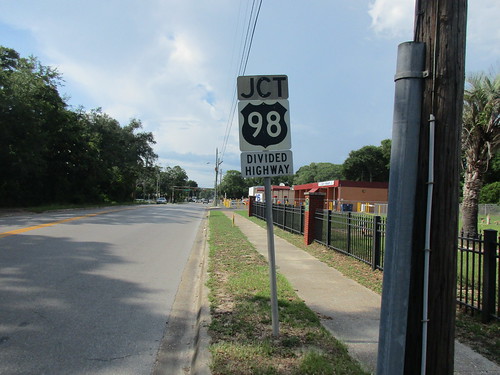
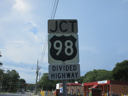
Surprisingly, in 2018 prior to Michael, there were quite a few US 98 "kodachrome" shields left around Panama City. This one,
which used to stand next to a railroad crossing I had documented for a site I help run, appears to have sadly been another loss from Michael,
per street view:
 IMG_9607
 by
freebrickproductions, on Flickr
 IMG_9608
 by
freebrickproductions, on Flickr
 IMG_9609
 by
freebrickproductions, on Flickr
Next, we have two assemblies that once stood along Frankford Avenue in the western part of Panama City. According to
street view imagery, this first one did amazingly manage to survive Michael's Cat. 5 landfall just to the east of here, but was still sadly removed some time prior to 2022:
 IMG_9905
 by
freebrickproductions, on Flickr
 IMG_9906
 by
freebrickproductions, on Flickr
 IMG_9907
 by
freebrickproductions, on Flickr
Just up the street was also this pair of shields, with cardinals posted above them.
Street view from 2022 shows that they also amazingly survived Michael, though they did lose the arrows in the process, it appears.
Nearby 2023 imagery seems to indicate that they may still be there.
 IMG_9908
 by
freebrickproductions, on Flickr
 IMG_9909
 by
freebrickproductions, on Flickr
 IMG_9910
 by
freebrickproductions, on Flickr
Going back towards the northern part of Panama City now, and closer to where Michael made landfall (on the other side of Tyndall Air-force Base), was this "kodachrome" shield on Sherman Avenue.
Per 2022 street view, this one also amazingly survived the hurricane as well:
 IMG_8903
 by
freebrickproductions, on Flickr
 IMG_8908
 by
freebrickproductions, on Flickr
 IMG_8905
 by
freebrickproductions, on Flickr
Finally, to wrap-up the tour of "kodachrome" shields around Panama City, there used to be this US 98 Business shield along 3rd Street in Springfield, FL. Sadly, it appears that this was once again lost due to Hurricane Michael, but it appears that
the post somehow still survives:
 IMG_9136
 by
freebrickproductions, on Flickr
 IMG_9140
 by
freebrickproductions, on Flickr
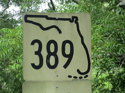
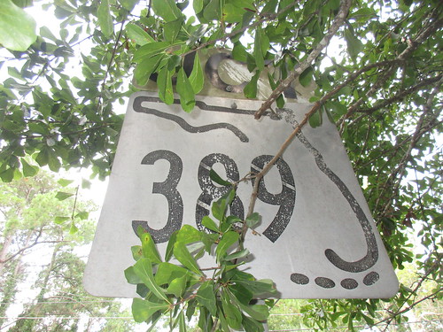
In the 1970s (IIRC), due to Florida's state-maintained highway mileage cap, the state turned-over many of its State Roads to the counties, often being the more minor routes like the suffixed spur routes and a large number of the three-digit routes, along with the entire secondary system (indicated by an S before the route number). As a result of this, most of the signed county routes within Florida also have wound-up slotting nicely into Florida's well-organized numbering system. This is notable, as not only did this mass-turnover to to the counties help let a number of the older "kodachrome" shields above survive, but the 1970s (though possibly later), was also when Florida redesigned their state highway shields, IIRC. Prior to this redesign, the shields featured a representation of the Florida Keys along the bottom of them, which were dropped as a result of the redesign. These "keys shields", as referred to by roadgeeks here in the US, can still occasionally be found on the former state roads if you know where to look.
This first "keys shield" is a particularly well-preserved example, located in northern Panama City for the still-extant FL 389.
Per street view, this one as also thankfully spared Michael's wrath. On the back of these signs, you could also still find a stamped date from 1974, no doubt when the signs were originally made.
 IMG_8863
 by
freebrickproductions, on Flickr
 IMG_8864
 by
freebrickproductions, on Flickr
 IMG_8865
 by
freebrickproductions, on Flickr
 IMG_8866
 by
freebrickproductions, on Flickr
 IMG_8867
 by
freebrickproductions, on Flickr
A bit further back was another FL 389 keys shield, though it was partially obscured by a tree.
This one also managed to initially survive Michael, but has sadly since been removed.
 IMG_8871
 by
freebrickproductions, on Flickr
 IMG_8872
 by
freebrickproductions, on Flickr
 IMG_8874
 by
freebrickproductions, on Flickr
Next, going east to Mexico Beach, there was this FL 386 keys shield along 15th Street (CR 386A). Amazingly, despite being super close to where Hurricane Michael made landfall,
this shield had survived the hurricane, though twisted towards the road. Sadly, per more recent street view imagery, it has since been removed. Admittedly, like many surviving key shields, this one had been in pretty poor shape when I visited it back in 2016.
 FL 386 Keys Shield
 by
freebrickproductions, on Flickr
 FL 386 Keys Shield
 by
freebrickproductions, on Flickr
 FL 386 Keys Shield
 by
freebrickproductions, on Flickr
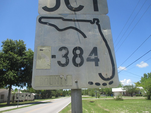
Continuing east over to Port St. Joe, you can find this old keys shield in the southeast corner of the city. This one was originally for FL S-384, which was a secondary highway. When it was turned-over to the county, it was patched with the appropriate county patches (becoming C-384), though those have since faded off. The shield is still in pretty good shape otherwise. Unlike the lost US 98 "kodachrome" shield nearby, this was thankfully not lost due to the hurricane,
and still stood as of 2023.
 FL C-384 Keys Shield
 by
freebrickproductions, on Flickr
 FL C-384 Keys Shield
 by
freebrickproductions, on Flickr
 FL C-384 Keys Shield
 by
freebrickproductions, on Flickr
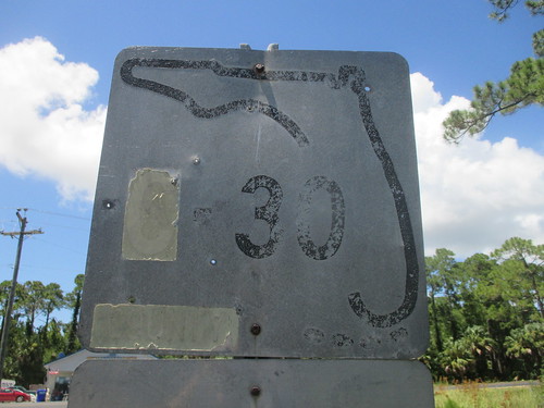
Further east, between Cape San Blas and Indian Pass is another keys shield, still standing along CR 30B. It appears this was originally for FL S-30 originally, and was also patched into a county shield upon the retirement of the secondary highway system in 1977. This one's in pretty poor condition, though, like with the one above,
it was still around as of last year. It appears that part of FL S-30 in this area was retained on the state system as FL 30A, with the rest becoming CR 30A. Cape San Blas is still served by FL 30E as well, which I believe is the highest-surviving suffix on Florida's highway system.
 FL C-30 Keys Shield
 by
freebrickproductions, on Flickr
 FL C-30 Keys Shield
 by
freebrickproductions, on Flickr
 FL C-30 Keys Shield
 by
freebrickproductions, on Flickr
Finally, near the community of Cypress, FL, is another worn-out keys shield, still posted along the secondary route it was on.
This one also still stands as of 2023, though, with the lean of the post now, and the fact that all but the county patches are now nearly worn-off, its days may be numbered.
 FL C-275 Keys Shield
 by
freebrickproductions, on Flickr
Probably busy documenting grade crossings in the southeastern United States.
(They/Them)


