A5159
| A5159 | ||||
 | ||||
| From: | Watling Street (SK053065) | |||
| To: | Brownhills Interchange (SK044073) | |||
| Distance: | 0.6 miles (1 km) | |||
| Met: | A5, M6 Toll | |||
| Now part of: | A5195 | |||
| Traditional Counties | ||||
| Route outline (key) | ||||
| ||||
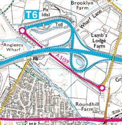
The DfT listed the A5159 as a link between the A5 and M6 Toll in Staffordshire in 2005, and was the link road between junction T6 and the A5 built during the M6 Toll construction works. However, by 2009 it was now part of the A5195, of which nearly half had been the A5159.
It is not known at this stage why this road had two such similar numbers allocated to it in such a short period of time. It is speculated that one or the other number may have been a typing or transposition error, though it would seem more likely that the lower number of the two would have been used permanently.
This page includes a scan of a non-free copyrighted map, and the copyright for it is most likely held by the company or person that produced the map. It is believed that the use of a limited number of web-resolution scans qualifies as fair use under United States copyright law, where this web page is hosted, as such display does not significantly impede the right of the copyright holder to sell the copyrighted material, is not being used to generate profit in this context, and presents information that cannot be exhibited otherwise.
If the copyright holder considers this is an infringement of their rights, please contact the Site Management Team to discuss further steps.


