B2089
| B2089 | ||||
| Location Map ( geo) | ||||
| ||||
| From: | Vinehall Street (TQ757202) | |||
| To: | Rye (TQ918203) | |||
| Distance: | 11.1 miles (17.9 km) | |||
| Meets: | A21, B2090, B2165, A28, A268 | |||
| Highway Authorities | ||||
| Traditional Counties | ||||
| Route outline (key) | ||||
| ||||
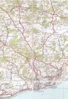
The B2089 is the corridor between the South of Kent and the Heart of 1066 Country in Eastern East Sussex. It has its ups and downs but travels mainly along the ridge of the Tillingham and Brede Valleys. It has never changed numbers and has kept its original route throughout its life.
Route
The road starts on a western junction in a triangle with the A21 and B2090 in the hamlet of Vinehall Street, heading up to the junction with the unsigned and uncredited B2090 itself, forming the rest of this triangle. The road heads through woodland before emerging in Cripps Corner, greeted with a wide view on the north side. The road crosses the former A229 (now the B2244) over a narrow-bottomed brick arch bridge, before meeting the B2165 at a Stop/Give Way crossroads outside The White Heart Pub.
The B2089 then skirts and goes through part of Brede High Wood towards Broad Oak, where it meets the A28 at another Stop/Give Way crossroads, outside Broad Oak's Local Corner Shop. From there, the road passes through the main part of Broad Oak and onto Broadland Row; a straight row of housing. The road twists along the ridge with another great view on the South side this time, then meeting the illusive 'Tree-Rex' before heading into a small wood (you have to see it to know what it is).
Udimore is the next village, which is based mainly around the road and not onto any housing estates. Passing Tibbs 'Pick Your Own' Fruit Farm and the hamlet of Cock Marling, the road is out into more open area with a view to the English Channel that was best saved until last. The final descent down to the centre of Rye sees the road negotiate a fairly new mini-roundabout and dive into the row of housing, with drivers having to negate parked cars on one side.
Finally, the road twists where it crosses over the River Tillingham, before crossing The Marshlink Line at Ferry Road Level Crossing. A sharp left a few yards further on, the road ends by merging into the A268 one-way system in Rye. Traffic must head north via the station to reach Cinque Ports Street (the pre-bypass A259) and the new alignment of the A259.


