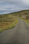
B887
| B887 | ||||
| Location Map ( geo) | ||||
| ||||
| From: | Ardhasaig (Aird Asaig) (NB137034) | |||
| To: | Hushinish (Huisinis) (NA990120) | |||
| Distance: | 12.7 miles (20.4 km) | |||
| Meets: | A859 | |||
| Highway Authorities | ||||
| Traditional Counties | ||||
| Route outline (key) | ||||
| ||||
For the former B887 from Portree - Staffin on Skye, see B887 (Skye).
Route
There are only three classified roads in North Harris: the A859, the diminutive A868, and the stunning B887. At about 13 miles long it is not the longest dead-end Scotland has to offer, but it is certainly one of the most beautiful.
The road commences at a junction with the A859 about three miles west of Tarbert, near to Ardhasaig (Aird Asaig). It quickly winds around the head of Loch Bun Abhainn Eadarra, past the ruinous remains of the old Whaling Station, to climb over the low hills to Loch Miavaig. Here it drops sharply down to the lochside, before running inland around the head of the narrow loch and doubling back up the other side, climbing steadily up the hillside past the scattered cottages of the village.
Over another low hill, the road passes the tiny lonely school, named after Cliasmol but serving all of the communities along the road. Another mile, and the small settlement of Cliasmol itself is reached. No more than a few scattered houses and a small estate make up the village, and then the road is off winding through the hills once more, passing lochans of varying sizes before reaching the bank of the Abhainn Eabhal. A bridge carries the road over the narrow stream, which then tumbles down a narrow gorge alongside the road to a spectacular roadside waterfall as the stream falls into Loch Leosavay. The road, meanwhile, has crossed a cattle grid between a pair of imposing gateposts.
All is revealed just around the corner, where the castle appears ahead. The road actually runs past the front door of the castle, separating it from its immaculate lawns on the lochside. Just beyond the castle, the road passes through another set of gateposts and runs past the cottages of Abhainn Suidhe, the tiny village which is little more than the estate cottages for the castle. At the head of the loch, the road swings inland and climbs steadily up the shallow glen to the Govig (Gobhaig) turning, which lies roughly at the summit of this last section of the route.
Heading downhill now, the road drops into Beitearsaig, just above the shore. Below is an elegant sweep of beach, curving around Bagh Huisinis, and just beyond a small parking area, the road itself is swamped by sand from the extensive dunes. A right turn crosses the narrow neck of land to the pier for Scarp, where the rocket post trials took place. The road actually ends at a T-junction in front of the houses, although with so much sand on the tarmac you'd be forgiven for not believing it!
History
This road was not classified in 1922, and indeed the base map for the 1923 MOT Map (which is probably c. 1900 +/-10) shows the road beyond Amhuinnsuidhe Castle as a mere path. However, by 1932 the original B887 on Skye had been consumed by the A855, and the number reallocated to its present route, presumably after the road had seen some improvements!


