Brig O Turk
| Brig O'Turk | |||
| Location Map ( geo) | |||
 | |||
| |||
| From: | Callander | ||
| To: | Aberfoyle | ||
| Location | |||
| The Trossachs | |||
| County | |||
| Perthshire | |||
| Highway Authority | |||
| Stirling | |||
| Opening Date | |||
| c1451, 1796 | |||
| On road(s) | |||
| A821 | |||
| Crossings related to the A821 | |||
| Crossings related to the Trossachs Trail | |||
The current Brig O'Turk was built in 1796 as part of the improvements made to the Trossachs area at the time. It seems likely that, as with many other bridges elsewhere, the bridge was funded by the sale of forfeited Jacobite estates. There has been a bridge on the site since at least 1451, if not earlier but all previous examples were washed away by the storm flow of the River Turk. It is thought that previous structures were all wooden bridges.
The Bridge was built to maintain the route of the new road constructed to Loch Katrine in 1780. Even in those early days, the Trossachs had become popular with tourists, and the Brig O'Turk quickly became a famed location, a must see on the tourist trail, especially after Sir Walter Scott wrote of the area in the 1810s.
The Bridge
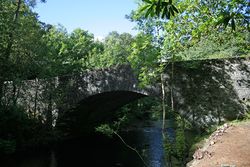
The Bridge itself is really a rather plain stone built structure. There is a single main arch spanning the river, with a secondary arch across the west bank to allow for storm surges. Apart from being widened in 1929, the bridge is much as it was built over 200 years ago. The low parapets, which curve round into wing walls, have been hit a few times over the years, resulting in some reconstruction, and some parts being completely removed. The road over the bridge is a narrow S2 with a pavement on the south side. However, thanks to the sharp bend on the west bank of the river, and a gentler one on the east bank, a lot of traffic treats the bridge as a single lane, pausing for oncoming traffic before crossing.
Brig O'Michael
Nearby, and hidden in the forest, is the Brig O'Michael, probably built at the same time. Today, it just carries a farm driveway and footpath, but when built it would have been an important crossing of the Black Water. As with the Brig O'Turk, the structure is a fairly plain stone arch, however as it has never really formed part of the local road network (since such responsibilities were assumed by local authorities and road traffic became common), it is still in 'as built' condition. This makes it an important example of how rural bridges in the area were constructed at the end of the 18th Century.
| Brig O Turk | ||
|


