Canderwater Interchange
| Canderwater Interchange | |||
| Location Map ( geo) | |||
| |||
| Location | |||
| N of Blackwood | |||
| County | |||
| Lanarkshire | |||
| Junction Type | |||
| Unique | |||
| Roads Joined | |||
| M74, A74, B7078 | |||
| Junctions related to the B7078 | |||
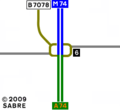
The former Canderwater Interchange, also known as Draffan Interchange (and often mis-spelt Draffen in lists of motorways in Scotland published by the government in the 1960s, 70s and 80s) was the southern terminus of the M74 for the first 20 years of that motorway's existence. It also had a 3-year prehistory as a junction on the A74. It was located between the present junctions 8 and 9.
It opened in 1963 as part of the Blackwood bypass on the A74. In December 1966 the first section of the M74 was opened, extending northward from this junction and absorbing a short section of 3-year-old A74. The junction was intended at that time to be the permanent southern end of the motorway, and was junction 1 in the original northward-increasing junction numbering system.
The interchange was located about one mile north of Blackwood, between the present junctions 8 and 9. Its mainline ran southwards from the M74 to what was then the A74 (since upgraded to form the present M74). The junction connected the mainline to the bypassed northward A74 (later renamed B7078) and local minor roads (Draffan Road to the east and Tanhill Road to the west).
The interchange was of an an unusual design. A driver who turned off either the northbound or southbound mainline, and remained on the nearly circular link road without turning off again, would end up going back to whence they had come. The most nearly similar junction extant today is probably on the A726 Glasgow Southern Orbital, a mile east of its junction with the M77.
The interchange was abolished in 1986 when the first southward extension of the M74 was opened. A new section of B7078 was built, going south from the site of the junction, to provide continued local access between Blackwood and the north.
Today there is no junction on the site. The bridge which formed part of the interchange still exists, and carries the M74 over a minor road without connection. Several vestiges of the former junction remain, with the eastern half being clear on aerial photography; though the western half was almost entirely destroyed when the new section of B7078 was added. There is very little sign of the junction from the motorway itself.
The early history of this junction explains the mystery of the split carriageways on the M74 to the north. Part of the western, now northbound, carriageway was built in 1963 as a single-carriageway realignment of the A74. The other carriageway, built in 1966, took a more direct line.
Strip Maps
| Canderwater Interchange | ||||||
| ||||||
| ||||||
|


