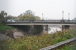
Chandos Bridge
| Chandos Bridge | |||
| Location Map ( geo) | |||
 | |||
| |||
| From: | East Quay | ||
| To: | Northgate | ||
| Location | |||
| Bridgwater | |||
| County | |||
| Somerset | |||
| Highway Authority | |||
| Somerset | |||
| Opening Date | |||
| 1871, 1983, 1988 | |||
| On road(s) | |||
| unclassified | |||
Chandos Bridge was built in 1988 to carry traffic across the Parrett to the north of Bridgwater Town Centre. However, it was not the first road crossing here, although the older crossing has an interesting history.
Black Bridge
The Black Bridge still spans the Parrett immediately to the north of the newer Chandos Bridge, but it was never intended as a road bridge. It was originally constructed in 1871 to carry part of the towns docks railway system across to West Quay. The design was a telescopic Iron trough which could be retracted to allow shipping to continue up the river. It appears to have been a rather convoluted method to open the bridge, and not strictly telescopic, certainly not like a radio ariel anyway! The bridge was re built in steel in 1907, and last opened in the mid-fifties.
The bridge itself crosses the river in almost a single span. A sturdy stone pier sits on the eastern river bank, with a drum shaped pier in the river near the western bank. By the 1970s the docks railway were in decline, and so the bridge was fixed in 1974 before being converted to carry a road and footway in 1982-3.
This was only a short lived situation however. The bridge was only wide enough for a single lane, leading to lengthy queues on either side waiting for the traffic lights. As the East Quay area was redeveloped to provide a retail park in the mid 1980s, so the traffic levels continued to increase, and with the town centre now pedestrianised, the Town Bridge was no longer a viable alternative. Finally, in 1988, the new bridge was opened providing a 20th century solution.
The New Bridge
Chandos Bridge is a fairly standard Concrete deck structure with the centre of 3 spans crossing the main river channel. As this section of the Parrett is tidal, however, the two side spans are needed at every high tide. The deck carries three lanes of traffic and two pavements, despite the old bridge being retained as a footbridge. The central traffic lane is used by right-turning traffic at the East Quay lights immediately beyond the bridge.
| Chandos Bridge | ||||
| ||||
|


