Churchill Barriers
| Churchill Barriers | |||
| Location Map ( geo) | |||
 | |||
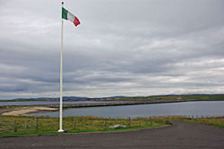
| This is the first Churchill Barrier seen from Lamb Holm | |||
| |||
| From: | Ayre of Cara | ||
| To: | West Breckan | ||
| County | |||
| Orkney | |||
| Highway Authority | |||
| Orkney Islands | |||
| Opening Date | |||
| 1945 | |||
| On road(s) | |||
| A961 | |||
The Churchill Barriers are a series of four causeways in Orkney linking the Orkney Mainland to the island of South Ronaldsay, via Lamb Holm, Glimps Holm and Burray. The Barriers were originally built as a war defence during the Second World War to protect Scapa Flow. They are now used to carry the single-carriageway A961 road.
The Barriers
The barriers were constructed by Prisoners of War during World War 2, and are constructed from a huge number of concrete blocks dumped in the shallow channels between the islands. The blocks were created from stone quarried on Lamb Holm, where the POW camp was sited. Once completed, smaller blocks were laid on top to form a roughly level surface on which the road could be constructed. Whilst providing a two-way road, the barriers are generally quite narrow by modern standards and can be quite tricky to negotiate with spray raining down!
Barrier No 1
The first Barrier, heading south from the Orkney Mainland, is almost half a mile long and crosses from the mainland to Lamb Holm. At the northern end of the barrier, the B9052 meets the A961, the latter having been extended westwards from the Pier in St Mary's when the barrier had opened. Previously, a ferry served between Mainland and Burray, with no regular access to Lamb Holm or Glimps Holm. Lamb Holm is, of course, home to the world famous Italian Chapel, the last surviving remnant of the prisoner of war camp that was constructed to house the men building the barriers.
Barrier No 2
The second Barrier connects the two small isles of Lamb Holm and Glimps Holm. It is almost exactly the same length as Barrier No 1 and features a concrete wall along the eastern side of the road at the north end to protect traffic from some of the more severe weather, which regularly flings sea water across the road in stormy conditions. Lying in the water to the east of the barrier is one of the blockships that was sunk before the barrier was built.
Barrier No 3
Running from Glimps Holm to Burray, this is the shortest of the barriers. It crosses the Weddell Sound, where a number of the Blockships can be seen lying to the east of the barrier. Prior to its construction, there were no classified roads on Burray (nor indeed the previously uninhabited Holms), so the extension of the A961 takes a slightly wiggly course across the narrow neck of the island.
Barrier No 4
Connecting Burray to South Ronaldsay and replacing a ferry that originally ran further west from the pier in Burray Village to the end of the B9044, Barrier No 4 is the only one to have been reclaimed by nature. Significant sand dunes have built up on the eastern side of the barrier, creating more of a problem than spray does on the other barriers as it is constantly blowing and sliding into the road. As yet, there doesn't seem to be any attempt to minimise this issue by building a retaining structure along the roadside. The opening of the Barriers led to the A961 being extended the length of South Ronaldsay, mostly taking over the former B9040, but also using a newly built section of road to connect to the barrier itself.
History
Following the sinking of the battleship HMS Royal Oak by a German U-boat in 1939, Winston Churchill ordered permanent barriers to be constructed to block the eastern entrances to Scapa Flow. The narrow channels had already been partially blocked by blockships - old boats deliberately scuttled to minimise the chances of U Boats finding a way in, but one did. Work began on the barriers in 1940, with most of the labour provided by Italian prisoners of war. The barriers were completed in September 1944, although the official opening of the Barriers did not happen until May 1945.
Links
| Churchill Barriers | ||||||||
| ||||||||
| ||||||||
|


