Dunoon Road End
| Dunoon Road End | |||
| Location Map ( geo) | |||
 | |||
| |||
| Location | |||
| Near Cairndow | |||
| County | |||
| Argyll | |||
| Highway Authority | |||
| Transport Scotland | |||
| Junction Type | |||
| T Junction | |||
| Roads Joined | |||
| A83, A815 | |||
| Junctions related to the Argyll Coastal Route | |||
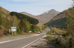
A little to the east of Cairndow, along the A83, the A815 turns off to head south across the Cowal Peninsula eventually reaching Dunoon. The junction is locally known as Dunoon Road End, as it is the only road access to the Clyde coast town - there are a couple of ferries which ply the Firth of Clyde. The junction is a simple give way, with a central turning lane on the A83, a filter left turn lane, and lanes for left and right turning traffic leaving the A815. The A815 then drops steadily down, crossing the Allt Kinglas on a substantial embankment before turning along the opposite side of the glen.
History
The junction used to lie a little further to the west, nearer Cairndow village. Extensive re-alignment works were undertaken over 20 years ago to not only improve the junction, but also the two roads. The old alignment of the A83 is clear to see, running to the south and roughly parallel to the new road for some distance up Glen Kinglas. However, the old A815 is now hidden in the trees to the west of the modern junction.
In fact the A815 met the A83 twice here. After climbing up from the Allt Kinglas Bridge, one arm continued west to meet the Inveraray Bound A83, while the other hairpinned vertically below the A83, which is propped up on a retaining wall. Whilst this hairpin has very little gradient, it requires quite a large swing area for traffic to turn back to the east. At no point do any of the roads appear to exceed 18 feet or about 5.5m in width, which is roughly the width that Caulfeild built his military road 250 years ago. It is therefore perhaps unsurprising that the junction and roads needed some improvement!
Old mapping show an intriguing history with the junction. The OS Six Inch Map originally just shows the western arm of the A815, with a sharp fork at the Cairndow end in the 1870s. However, by the 1890s both arms are shown, and the way that the junction is drawn seems to suggest that the eastern arm, facing up to The Rest now has priority. Unfortunately, the next map that has been found with sufficient detail is the OS One Inch Sheet from 1956 (earlier One Inch sheets show a simple T junction, which was never the case). By the 1950s, only the western arm, facing Cairndow, is depicted, again with an impossibly sharp fork for traffic coming down Glen Kinglass. By 1965, the detailing of the map for the A83 has been changed (now showing a cutting and embankment), suggesting that the new alignment of the road up the glen has been opened, but the junction with the A815 is unchanged. On the ground, the eastern end of the junction is still readily accessible from the A83, while the western end is buried below the modern road, which suggests the reverse situation to the map. However, it is possible that the road was upgraded up the glen, but that a short section between Cairndow (bypassed before 1936) and the junction was left until later, but this seems unlikely. Much of this is probably an effect of trying to show the detail on the map at too small a scale, and perhaps unhelpful in precisely dating the changes.
The junction is still there for the intrepid explorer to find, accessed through a gate to the west of the modern junction. The old road is used as a gravel/chippings storage area, and beyond it is becoming increasingly overgrown (since the photos were taken in 2012), although the tarmac is still clear apart from the extreme western end. Below the junction, the old A815 drops down to cross the Allt Kinglas Bridge, with sharp bends at either end, before returning up the other side of the glen to meet its new route. However, the fallen trees are much worse on this side of the river, and there doesn't appear to be any direct link between the old and new roads.
Routes
| Route | To | Notes |
| Glasgow (A82) | Argyll Coastal Route | |
| Campbeltown | Argyll Coastal Route | |
| Dunoon, Colintrave Isle of Bute Ferry (A886) |
| Dunoon Road End | ||
| ||
|


