Star.pngStar.pngStar grey.pngStar grey.pngStar grey.png

A1051

From Roader's Digest: The SABRE Wiki
Jump to navigation Jump to search
A1051
Location Map ( geo)
Cameraicon.png View gallery (1)
From:  Hallgarth Street (NZ277416)
To:  Crossgate (NZ266423)
Distance:  1.1 miles (1.8 km)
Met:  A177, A1050, B1282, A690
Now part of:  A177
Traditional Counties

Durham

Route outline (key)
A1051 Link in Durham
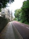
The now-unclassified former A1051 passing Durham School

The A1051 was a short road to the south of Durham city centre. Although narrow, it must have been well-used as it avoided the incredibly busy Market Place.

The road started on the A177 Hallgarth Street and headed west along Stockton Road before crossing the A1050 and coming into view of the River Wear. It turned sharply left next to Durham School before ending on the A690 at the top of Crossgate.

When roads in Durham were improved in the 1980s, the A1051 disappeared. The easternmost section is now part of a rerouted A177, the rest is unclassified.



A1051
Related Pictures
View gallery (1)
Durham School, Quarryheads Lane (C) Roger Smith - Geograph - 557712.jpg
Other nearby roads
Durham
A1(M) • A167 • A177 • A180 (Durham - Byers Garth) • A181 • A688 • A690 • A691 • A1050 • B1198 • B1282 • B1283 • B6291 • B6300 • B6302 • B6532 • E15 • E31 (via Newcastle) • M100 • T1 (Britain)
A1000-A1099
A1000 • A1001 • A1002 • A1003 • A1004 • A1005 • A1006 • A1007 • A1008 • A1009 • A1010 • A1011 • A1012 • A1013 • A1014 • A1015 • A1016 • A1017 • A1018 • A1019
A1020 • A1021 • A1022 • A1023 • A1024 • A1025 • A1026 • A1027 • A1028 • A1029 • A1030 • A1031 • A1032 • A1033 • A1034 • A1035 • A1036 • A1037 • A1038 • A1039
A1040 • A1041 • A1042 (N) • A1042 (S) • A1043 • A1044 • A1045 • A1046 • A1047 • A1048 • A1049 • A1050 • A1051 • A1052 • A1053 • A1054 • A1055 • A1056 (N) • A1056 (S) • A1057 • A1058 • A1058(M) • A1059
A1060 • A1061 • A1062 • A1063 • A1064 • A1065 • A1066 • A1067 • A1068 • A1069 • A1070 • A1071 • A1072 • A1073 • A1074 • A1075 • A1076 • A1077 • A1078 • A1079
A1080 • A1081 • A1082 • A1083 • A1084 • A1085 • A1086 • A1087 • A1088 • A1089 • A1090 • A1091 • A1092 • A1093 • A1094 • A1095 • A1096 • A1097 • A1098 • A1099
Earlier Uses: A1000 • A1001 • A1010 • A1016(N) • A1016(S) • A1018(S) • A1018(N) • A1019 • A1020 • A1021 • A1022 • A1023 • A1025 • A1027 • A1032(N) • A1032 (S) • A1037
A1041(N) • A1041(S) • A1053 • A1054 • A1055 • A1056 • A1057 • A1059 • A1060 • A1062 • A1063 • A1070(E) • A1070(W) • A1072 • A1074(E) • A1074(W) • A1075 • A1076 • A1078
A1080 • A1081 • A1082 • A1089 • A1090 • A1096


SABRE - The Society for All British and Irish Road Enthusiasts
Discuss - Digest - Discover - Help