A1159
| A1159 | ||||
| Location Map ( geo) | ||||
| ||||
| From: | Bournes Green (TQ910864) | |||
| To: | Southend Airport (TQ874887) | |||
| Distance: | 3.5 miles (5.6 km) | |||
| Meets: | A13, A127, unclassified | |||
| Highway Authorities | ||||
| Traditional Counties | ||||
| Route outline (key) | ||||
| ||||
The A1159 connects the eastern suburbs of Southend-on-Sea with the town's airport.
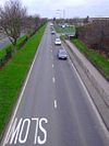
The road starts at a roundabout on the A13 in the Bournes Green area of town, not far from that road's eastern end in Shoeburyness. The A1159 heads northwest, along the D2 Royal Artillery Way, which skirts the edge of the urban area. Although there are houses to the left, they are set back and not accessible from this road.
After bending to the left a roundabout is reached, which provides access to these suburbs and the golf course to the north. After the roundabout the houses on the left get closer - but are still not accessible from the A1159, although the college to the right is. A narrow exit does then provide access to the service road, after which we reach another roundabout, for the hospital. From this point on the houses on the left front onto the A1159 and there is a gap in the central reservation to serve a side street.
After the next roundabout the road narrows to S2 to cross the Great Eastern railway line into Southend, after which it bends sharply right to skirt Priory Park, site of Prittlewell Priory. The A127 is met at the next roundabout and the two roads cannon off each other, with the A1159 turning right to continue north. It follows the residential Manners Way, which amazingly is the main access to (London) Southend Airport. The road ends at the next roundabout at the entrance to the airport complex. All other roads here are unclassified.


