Star.pngStar.pngStar grey.pngStar grey.pngStar grey.png

A1309

From Roader's Digest: The SABRE Wiki
Jump to navigation Jump to search
A1309
A1309.png
Cameraicon.png View gallery (10)
From:  Trumpington (TL440534)
To:  Milton (TL469620)
Via:  Cambridge
Distance:  6.2 miles (10 km)
Meets:  M11, A10, A1301, A1134, A14, A10
Primary Destinations
Highway Authorities

Cambridgeshire

Traditional Counties

Cambridgeshire

Route outline (key)
A1309 Trumpington - Cambridge
(A603, A1134) Cambridge
A1309 Cambridge - Milton

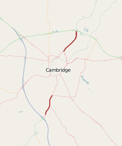
The A1309 follows the former route of the A10 through Cambridge, although it is only well-defined at its ends due to the dominance of other roads it multiplexes with inside the city's ring road. Through traffic on the A10 is now signed to use the M11 and A14 instead.

Approaching M11 near Cambridge

The A10 is left behind at M11 J11 and heads northwards into town. A dualled section leads to traffic lights where a spur of the A1301 heads off to the right and a slip road peels off to the left to access the Park and Ride. Full access is provided at the next set of traffic lights. The road then goes over the Cambridgeshire Guided Busway (used by park and ride buses), then adjacent sets of traffic lights provide access to Waitrose and the mainline of the A1301.

The road continues north along Trumpington High Street. As the road leaves the village and becomes more rural again a set of traffic lights is reached on the A1134 Cambridge Ring Road, which is some distance from the city centre on this side. The southern section of the A1309 ends here as roads inside the ring road take precedence. Through traffic on the A1309 would continue ahead along the A1134.

The former A10 continues into the city centre along the present A1134 Trumpington Road. When that road bears left along The Fen Causeway, the quickest way back to the A1309 is to turn right along the A603, which skirts the eastern side of the city centre to rejoin the A1134 just to the south of the River Cam. Following the A1134 across the river leads to a roundabout in the suburb of Chesterton, where the A1309 finally reappears after over 3 miles in a multiplex.

History
Lesson
The original route of the A10 continued from Trumpington Road into the now-unclassified Trumpington Street before running into those city-centre roads that all vehicles are dissuaded from using. At the top end of Trinity Street it joined the A45/A604 multiplex on Bridge Street and all three roads multiplexed over the River Cam onto Magdalene Street. The three roads diverged at the next crossroads: A45 left, A604 ahead, A10 right. It followed the river along Chesterton Road before bearing left at Mitcham's Corner to follow the A1134 Milton Road to reach the A1309 again.

The A1309 continues northeastwards along Milton Road through the suburbs. On the edge of town the Guided Busway turns left at traffic lights at what used to be a level crossing, then the Cambridge Science Park is passed. A short dualled section leads to A14 J33, where the A1309 ends and the A10 reappears.


A1309
Junctions
Roads
Places
Related Pictures
View gallery (10)
Hauxton Road & pointed friends - Geograph - 767806.jpgCycle path out of Cambridge - Geograph - 767781.jpgA1309 Milton Road (old A10) - Coppermine - 8580.jpgA14 Junction - Coppermine - 4337.jpgJoining junction 11 of the M11 - Geograph - 1486712.jpg
Other nearby roads
Cambridge
NCN51 • A10 • A14 • A45 • A130 • A132 (Colchester - Huntingdon) • A428 • A603 • A604 • A1120 (Cambridge) • A1131 • A1132 • A1134 • A1301 • A1303 • A1307 • B1045 • B1046 • B1046 (Cambridge) • B1047 • B1047 (Cambridge) • B1048 (Cambridge) • B1049 • C194 (Cambridgeshire) • C195 (Cambridgeshire) • C200 (Cambridgeshire) • C201 (Cambridgeshire) • C202 (Cambridgeshire) • C213 (Cambridgeshire) • C233 (Cambridgeshire) • C234 (Cambridgeshire) • C235 (Cambridgeshire) • C237 (Cambridgeshire) • C248 (Cambridgeshire) • C279 (Cambridge, Cambridgeshire) • C280 (Cambridgeshire) • C281 (Cambridgeshire) • C286 (Cambridgeshire) • C287 (Cambridgeshire) • C289 (Cambridgeshire) • C290 (Cambridgeshire) • C291 (Cambridgeshire) • C292 (Cambridgeshire) • C294 (Cambridgeshire) • C296 (Cambridgeshire) • E15 • E24 • E28 (Birmingham - Ipswich) • E112 (Old System) • M11 • T31 (Britain) • T45 (Britain)
A1300-A1399
A1300 • A1301 • A1302 • A1303 • A1304 • A1305 • A1306 • A1307 • A1308 • A1309 • A1310 • A1311 • A1312 • A1313 • A1314 • A1315 • A1316 • A1317 • A1318 • A1319
A1320 • A1321 • A1322 • A1323 • A1324 • A1325 • A1326 • A1327 • A1328 • A1329 • A1330 • A1331 • A1332 • A1333 • A1334 • A1335 • A1336 • A1337 • A1338 • A1339
A1340 • A1341 • A1342 • A1343 • A1344 • A1345 • A1346 • A1347 • A1348 • A1349 • A1350 • A1351 • A1352 • A1353 • A1354 • A1355 • A1356 • A1357 • A1358 • A1359
A1360 • A1361 • A1362 • A1363 • A1364 • A1365 • A1366 • A1367 • A1368 • A1369 • A1370 • A1371 • A1372 • A1373 • A1374 • A1375 • A1376 • A1377 • A1378 • A1379
A1380 • A1381 • A1382 • A1383 • A1384 • A1385 • A1386 • A1387 • A1388 • A1389 • A1390 • A1391 • A1392 • A1393 • A1394 • A1395 • A1396 • A1397 • A1398 • A1399
Earlier iterationsA1301


SABRE - The Society for All British and Irish Road Enthusiasts
Discuss - Digest - Discover - Help