A4225
| A4225 | ||||
 | ||||
| From: | Porth (ST023914) | |||
| To: | Trehafod (ST035910) | |||
| Distance: | 0.9 miles (1.4 km) | |||
| Meets: | A4233, A4058 | |||
| Former Number(s): | A4058 | |||
| Old route now: | B4278 | |||
| Highway Authorities | ||||
| Traditional Counties | ||||
| Route outline (key) | ||||
| ||||
Route

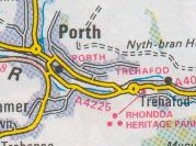
The A4225 was a short link road in the Glamorgan village of Porth, which existed in the 1980s and for possibly longer on the original line of the A4058 through town. That route has now been downgraded to become part of the B4278 but there is evidence that the A4225 number still exists in the area.
This may be no more than a mapping error, however, as the only current reference to it appears to be on Google Earth (and presumably any other on-line maps sharing the same data).
History
Before the road network around Porth was rationalised, the A4058 passed through Porth itself with the B4278 ending on the western side of the village. The A4233 also used to follow a different alignment, its current route being that of a former railway line. As such, both A-roads passed through the middle of Porth, crossing towards the north, and they were connected to the south by another road marked as A-class. This ran along Eirw Road and Pontypridd Road and large-scale maps of the time give this the A4225 number.
Now that the town has been bypassed, mainly by using old railway trackbeds, Google have transferred this number to the new road, so that the A4058 stops where it used to turn into the town, as does the A4233 where it has been diverted to meet the new road, both re-emerging where their multiplex ends. If this road is indeed still the A4225, it has to be one of the most unnecessary multiplexes in the country!
| A4225 | ||
| ||
|
This page includes a scan of a non-free copyrighted map, and the copyright for it is most likely held by the company or person that produced the map. It is believed that the use of a limited number of web-resolution scans qualifies as fair use under United States copyright law, where this web page is hosted, as such display does not significantly impede the right of the copyright holder to sell the copyrighted material, is not being used to generate profit in this context, and presents information that cannot be exhibited otherwise.
If the copyright holder considers this is an infringement of their rights, please contact the Site Management Team to discuss further steps.

