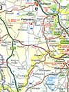
A5012
| A5012 | ||||
| Location Map ( geo) | ||||
| ||||
| From: | Newhaven SK17 (SK166602) | |||
| To: | Cromford (SK296569) | |||
| Distance: | 9.6 miles (15.4 km) | |||
| Meets: | A515, B5056, B5023, B5036, A6 | |||
| Former Number(s): | B5055, B5036 | |||
| Highway Authorities | ||||
| Traditional Counties | ||||
| Route outline (key) | ||||
| ||||
For the original incarnation in Shropshire, see A5012 (Shrewsbury).
The A5012 is a largely rural road in west Derbyshire. Originally numbered B5055, it gained its current number in 1935.
The road starts on a T-junction with the A515 at Newhaven. This hamlet was formerly a common motorbiking stop but became more upmarket and now is eerily quiet! Shortly after the junction there is a left turn to Youlgreave; this is now unclassified, but was originally the B5056, and subsequently the A524 though why is mystifying: it is single-track under a few railway bridges, now disused, and extremely narrow through Youlgreave (pronounced – and sometimes spelt – Youlgrave) and Middleton itself.
Anyway, the A5012 continues south-eastward. It is a reasonably wide S2 for the Peak District. It goes through Pikehall, then a fork in the road avoids the turn to Winster – there is a crossroads further down for Newhaven-bound traffic as the turn is tight. After the crossroads with the B5056 – again formerly the A524 – with one way leading back to the A515 and Ashbourne, the other to Rowsley, the road enters the Via Gellia valley. This valley abounds in quarries, stone-works and the like, and the road surface can consequentially become both stony and wet, and is often slippery. Coupled with the many sharp bends and the narrowness of the carriageway, there is a recently imposed 40 mph speed limit. The road is incredibly scenic, nevertheless, and is a pleasant drive. A turn for the B5023 towards Wirksworth (erroneously signed on the finger boards as A5023) is the only intersection encountered on the run through the valley.
The road still narrow, we enter Cromford, famous for its association with Richard Arkwright: his Masson Mill is just outside the village on the A6 to Matlock, and is now a shopping centre and car park. A brief passage through the village leads to a TOTSO with the B5036 towards Wirksworth. Despite its classification, this and the B5023 to the south of Wirksworth (towards Ashbourne) were evidently designed for quarrying traffic and are therefore reasonably well built and wide. Shortly afterwards, the road ends at a signalled junction with the A6.


