A5125 (Leicester)
| A5125 | ||||
 | ||||
| From: | Braunstone (SK569027) | |||
| To: | Abbey Park (SK591056) | |||
| Via: | Frog Island | |||
| Distance: | 3.6 miles (5.8 km) | |||
| Met: | A46, A47, A50, A5131, A6 | |||
| Former Number(s): | B583 | |||
| Now part of: | B5327 | |||
| Traditional Counties | ||||
| Route outline (key) | ||||
| ||||
For the seemingly extant route in the centre of Loughborough, see A5125.
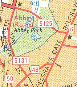
The A5125 bypassed Leicester to the west between Braunstone in the south and Abbey Park in the north. The road was upgraded from the B583 (although it was diverted at its northern end) in 1971. It spent a few later years as the A46 mainline but the road is now unclassified, apart from the northern end which is numbered B5327.
The road started on the A46 (now A5460) Narborough Road to the south of the city centre. It headed north along Fullhurst Avenue before bending a few times to cross the A47 Hinckley Road. After winding into Fosse Road North the road crossed the A50 Groby Road at a staggered crossroads.
The road continued along the dual-carriageway Blackbird Road, which bent sharply right to reach Abbey Lane. Whilst the B583 turned left here the A5125 continued ahead, with Abbey Lane numbered as the A5131. The road headed east past the abbey to cross the River Soar and skirt Abbey Park. It ended at a roundabout on the A6 (now A607) Belgrave Road.
This page includes a scan of a non-free copyrighted map, and the copyright for it is most likely held by the company or person that produced the map. It is believed that the use of a limited number of web-resolution scans qualifies as fair use under United States copyright law, where this web page is hosted, as such display does not significantly impede the right of the copyright holder to sell the copyrighted material, is not being used to generate profit in this context, and presents information that cannot be exhibited otherwise.
If the copyright holder considers this is an infringement of their rights, please contact the Site Management Team to discuss further steps.


