A5223 (Wellington)
| A5223 | ||||
 | ||||
| From: | Haygate (SJ638107) | |||
| To: | Wellington (SJ650120) | |||
| Distance: | 5.5 miles (8.9 km) | |||
| Met (1980): | A5, A442 | |||
| Former Number(s): | B5061 | |||
| Traditional Counties | ||||
| Route outline (key) | ||||
| ||||
For the current route of A5223 along the western edge of Telford, see A5223.
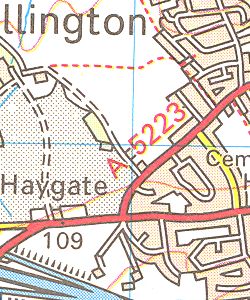
The original allocation of the A5223 number was to what started out as the B5061 in Wellington, western Telford.
The road started on the A5 Holyhead Road then headed into Wellington town centre along Haygate Road. It zigzagged into Market Street before crossing the railway line by the station. It then ran along Church Street and Park Street to end on the A442 Whitchurch Road.
The A5223 was an extremely short-lived upgrade whilst the New Town road network was in flux, before being downgraded to an unclassified route before 1982.
It seemingly only appears on the 1980 edition of the relevant Ordnance Survey Landranger sheet, and not on the revisions to either side; though it does appear in Bartholomew's mapping dated 1975. The A5223 number was in disuse for only a few years before being reallocated to the main north-south route along the western side of Telford.
| A5223 (Wellington) | |||||||
| |||||||
| |||||||
| |||||||
|
This page includes a scan of a non-free copyrighted map, and the copyright for it is most likely held by the company or person that produced the map. It is believed that the use of a limited number of web-resolution scans qualifies as fair use under United States copyright law, where this web page is hosted, as such display does not significantly impede the right of the copyright holder to sell the copyrighted material, is not being used to generate profit in this context, and presents information that cannot be exhibited otherwise.
If the copyright holder considers this is an infringement of their rights, please contact the Site Management Team to discuss further steps.


