A55/Route
The A55 is a major national trunk route which is a dual carriageway for its entire length (except for a short stretch of wide single carriageway over the Britannia Bridge, and a tiny bit in Holyhead).
Section 1: Chester – Colwyn Bay

The modern A55 starts where the M53 finishes, to the east of Chester, forming its Southern bypass, which at first runs parallel to the original A41 bypass. As the road circumnavigates Chester, it interchanges with the A51, A41, A483, A5104 and A550. At Ewloe, the road TOTSOs to the left, the A494 having the mainline through this junction, from the M56, bringing with it the bulk of traffic. The A494 multiplexes with us for half a mile, before it heads off to the south (eventually terminating in Dolgellau). Unfortunately the multiplex is short and through traffic on both roads is dumped into the wrong lane by the junctions, thus necessitating a lot of weaving.
We pass the first Gwasanaethau (Services) on the left. Most of the A55 is grade separated, and the early sections have a general motorway feel — it is easy to forget that fairly recently the A55 was a dog of a road, one long drag through one depressing Welsh village after another (Holywell, Abergele, others, with plenty of Llan-whatsits in there).
After Holywell, there is a fantastic sheer drop off the Clwyd range of hills (at Rhuallt, just before St Asaph), then we travel along the St Asaph bypass — one of the first bits to be upgraded, and very substandard — narrow, twisty, noisy, this continues round Abergele, where the sea becomes visible; we now follow the coast for some distance.
Section 2: Colwyn Bay – Bangor
Before long we join the Colwyn Bay bypass — referred to elsewhere as a secret motorway. This stretch has special road regulations, which are the same regulations as used on motorways. Because of this the speed limit on the special road is signed as 70mph (50mph through the town centre, because of noise). The road, opened in 1985, runs through cuttings and on embankments through Colwyn Bay, on the landward side of the railway, with extensive retaining walls, and through a cut-and-cover tunnel under the forecourt of the railway station. West of the station is a 3 km stretch where the road occupies the original railway alignment; the railway, reduced from four to two tracks, was diverted onto a new alignment alongside, Pictures
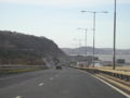
The A55 approaching Colwyn Bay
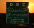
The NO Sign on the Colwyn Bay bypass


Before long we hit the A470 (Wales's Great North Road), and then the Conwy Bypass, with its superb snaking tunnel under the Conwy Estuary. Conwy is a pleasant little town, so much more now that it is not choked with traffic. The Conwy bypass opened in October 1991. The tunnel was constructed using the immersed tube technique, sections of the tunnel are sunk into place on the riverbed before being joined together. It was the first road tunnel of this type in the UK. The special road section ends west of the tunnel.
The next section is rather spectacular, snaking along the coast of North Wales, wedged between the cliffs and the sea. You must use two tunnels, passing through headland. Westbound traffic takes newer tunnels, while Eastbound takes the coastal route. The first of these tunnels is Penmaenbach, the Westbound tunnel opened in 1989, while the older tunnel on the Eastbound coastal route dates from 1932. Here the road is so twisty and narrow travelling on the old alignment, that a 30mph speed limit is applied. There is an even older route around the coast that is now just a footpath. The second tunnel is the Pen-y-Clip tunnel, the newer Westbound tunnel opened in 1993, while the coast route opened in 1935.
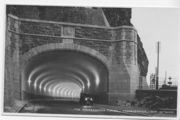
The original Penmaenbach tunnel
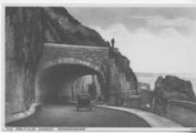
The original Pen-y-clip tunnel


There are two roundabouts on this section, one between the two tunnels at Penmaenmawr (the Puffin Roundabout), and another to the west of the Pen-y-clip tunnel, on the Llanfairfechan bypass. We continue to stay close to the coast, with wonderful vistas (on a clear day) of Snowdonia to the left. The stretch between Abergwyngregyn and Tai'r Meibion was built in the 1970s and has a wide grass central reservation, with the westbound carriageway having an undulating profile. From here the A55 used to take the now unclassified road to Llandygai where it met the A5. Continuing along the Bangor bypass we meet the present A5 at a GSJ. The A55 route used to terminate here, with the road continuing through the junction as A5 (which had to TOTSO), until the A55 was built across Anglesey in 2001.
Section 3: Bangor – Holyhead

The Bangor bypass ends at Britannia Bridge, a railway bridge across the Menai Straits. As originally built by Robert Stephenson it carried two rail tracks inside wrought iron box girders. After severe damage in a fire in 1970 it was rebuilt as a double-deck structure. The lower deck carries a single 2-way rail track which opened in 1972, alongside an access road for maintenance. The upper deck, opened in 1980 to relieve Telford's nearby Menai suspension bridge, carries the wide single carriageway of the A55. The whole is supported by new steel arches.
Once we hit Anglesey, we pass Llanfair PG (Llanfairpwllgwyngyll), the true name for the famous village with 50-odd letters, but which is actually an extension of the name which was made up by the railway company which built the line to Holyhead.
The Britannia Bridge road deck, the Llanfaipwllgwyngyll bypass and the western half of the Bangor bypass were originally opened as A5 but were renamed A55 in 2001 when the new dual carriageway was completed across Anglesey. The old route through the bypassed places and over Telford's bridge became A5 once more, and Telford's route across the island remained A5. Presumably, this was done to maintain the tradition of the A5 as the London-Holyhead road, on which brown heritage signage appeared at that time. Some have suggested it was also to maintain the road numbering zone boundary, but others think this implausible, especially as the A55 crosses the A5 a few times, meaning that by rights the road should have a number beginning with 4 (the A42 number should be free...). The western extension of the A55 crosses Anglesey on a line generally close to the A5, crossing it three times.
From Anglesey itself, the A55 crosses onto Holy Island alongside the existing causeway carrying the A5 and the railway line. The A55 now runs all the way into the port at Holyhead, so you can almost drive straight onto the Irish ferry from the A55. The final section is single carriageway through the town of Holyhead, turning right onto a bridge across the railway lines (straight on being the A5154), then left (at the A5, not that it is signed that) into the port where it terminates on a roundabout in front of the port buildings.
Original Author(s): Bob Sykes, revisions Paul Martin


