A9/route
The A9 is a strategic link from the Highlands of Scotland south to the Central Belt. Perhaps the most strtegic link. The Scottish Government have announced proposals to dual the whole route from Perth to Inverness, but commencement of work is still several years away at least!
Section 1: Polmont - M9 J11 (Dunblane)
Geographically Scotland can be divided into three principal areas, each associated with one of Scotland's three indigenous single-digit roads - the A7 crosses the Southern Uplands, the A8 stays in the lowlands, whilst the A9 is a creature of the Highlands. At 273 miles the A9 is the fifth longest A road in the UK, and the longest road to be entirely within Scotland, being 100 miles longer than its nearest rivals, the A82 and A90. It is also 50 miles longer than the combined length of Scotland's three other single digit roads (including the Scottish part of the A1).
The A9's history has some parallels with that of the A6. Neither of them ever reached the centre of the capital city that they notionally start from, originally branching off the A1 and A8 respectively in the outer suburbs. Both of them have since been truncated even further, now starting at Luton and Polmont respectively. However, the Zone 8/9 boundary more or less respects the old route of the A9.
The A9 originally started at the Costorphine junction on the A8 in western Edinburgh, following Craigs Road out of town. Later a diversion was built, staring on the A8 at the Maybury Roundabout, and following the Turnhouse Road to meet Craigs Road. Turnhouse Road now ends at the cargo terminal of Edinburgh Airport - the runway has completely obliterated the next section of the old A9, which re-emerges at Boathouse Bridge, over the River Almond. Still unclassified, this runs to Kirkliston, where it at last becomes a classified road, the B9080, which goes through Winchburgh to Linlithgow. In Linlithgow the route of the old A9 finally acquires A road status, albeit as the (non-primary) A803, which continues to junction 4 of the M9, and on to Polmont and Falkirk.
Meanwhile the present A9 starts, at last, at junction 5 of the M9. Because the M9 motorway continues to form the primary route as far as Stirling, the A9 is non-primary here. Most maps still show it ending again at the A904 Grangemouth Road, which runs into Falkirk. However, the A9 number has been adopted by the new Falkirk bypass (shown in yellow on this link to the Falkirk Wheel's website), which follows an old railway line for most of its route round the north side of the town to finally meet the original line of the A9 at the junction for the Falkirk Wheel - a 21st Century boat lift connecting the Union Canal and the Forth & Clyde Canal. Now at last on the original line of the A9, we multiplex briefly with the A803 dual carriageway to Camelon, where the A803 heads straight on towards Glasgow and the A9, now for the first time on its original route and unencumbered by multiplexes, turns purposefully northwards, to Larbert, junction 2 of the M876). On to Bannockburn (site of King Robert Bruce's famous victory over the English King Edward II). Next comes Stirling, ancient stronghold and until the construction of the Kincardine Bridge in the 1920s the first crossing of the River Forth. The A84 branches off west here, and the A91 to the east -- although the latter nowadays bypasses Stirling to the east, having already met the A9 further south at Bannockburn. The A9 then passes through Bridge of Allan to meet the terminus of the M9 at junction 11, just before Dunblane - a small cathedral city whose name will, for many, always be associated with the 1996 massacre at its primary school. We are now within sight of the geological fault known as the Highland Line which separates the central Lowlands from the Highlands. From this point the A9 gains trunk status - which it retains all the way to Scrabster - and becomes a dual carriageway, initially as the Dunblane bypass.
Original Author(s): T1(M)
Section 2: Dunblane - Perth
The original A9 ran from the terminal roundabout of the M9 into the middle of Dunblane on what is now the dual carriageway B8033. The new A9 runs to the west and north of Dunblane and is a grade separated dual carriageway. West of Dunblane, there is a diamond junction with the A820, which, in turn provides a link to the A84 at Callander and Rob Roy country. The A9 itself continues in a north-easterly direction towards Perth through Strathallan following an Old Military Road. At Greenloaning the Military Road heads north along the A822, but our course continues a further 6 miles eastwards to the world famous Gleneagles Hotel and Golf Course.
The road continues as a dual carriageway but the grade separated junctions give way to at-grade junctions. Eventually, we arrive at the northern terminus of the most northern motorway in Britain – the M90 spur at Perth. Continuing straight on at the M90 terminal roundabout, known as the Broxden Roundabout, will take you along the A93 through the centre of Perth. To stay on the A9 Perth western bypass you need to turn left. Average speed cameras are installed on this stretch.
Section 3: Perth - Inverness
The Perth western bypass marks the edge of the built up area of Perth. In addition to being a major trunk route, it provides access to the industrial estates of western Perth. To the north of the city another left turn at a roundabout is required to stay on the A9 which is still dual carriageway at this stage. Across the River Tay from this roundabout is the Palace of Scone – the site where the old Kings of Scotland were crowned before the union with England and Wales.
In August 2021 Luncarty to Pass of Birnam dualling was completed meaning there is now around 9 miles of continuous dual carriageway from Inveralmond roundabout northwards. North of here much of the original road has been bypassed by improved sections of road. Most of these are single carriageway but there are stretches of dual carriageway. From this point average speed cameras - 60 mph- are in position on all S2 sections as far as Inverness. Although controversial initially and many against their installation , they have regulated speed , and although there are still accidents they happen less. Traffic seems to flow and there are fewer dangerous overtaking manoeuvres. HGVs can also legally travel at 50mph with most seeming to drive on the limiter leading to fewer convoys. There are no static cameras on the D2 sections although mobile units can be seen occasionally.
As we travel north the number of tourist attractions increase. Soon we pass through the Tay Forest Park, following the River Tay and then the River Tummel to Pitlochry. Most of the junctions we pass are now either local accesses or A roads such as the A822 and A923 which are met at Dunkeld. The A9 used to cross the River Tay here on Telford's Bridge, but now crosses a mile or two further north.
These days, Pitlochry is bypassed, but the original route of the A9 ran through the town along the current A924. Like many Scottish towns, it is signed from the A9 with a sign that indicates that there is a bypass. The junctions themselves are single carriageway grade separated junctions. From Pitlochry we head north past Killiecrankie, where a famous battle was fought, into Glen Garry. The old A9 (now the B8079) runs on the left – a turning off that leads via the B8019 and the B846 to Loch Rannoch and Rannoch Station, which appears to be in the middle of nowhere on the Fort William Railway line. Unless you go to Rannoch you are now committed to 31 miles on the A9 with no other options to turn off.
We pass Blair Atholl and Blair Castle. The Duke of Atholl has the only private army in the United Kingdom. A little later we pass the falls of Bruar, and the House of Bruar which is an up-market retail ,comfort stop and food and beverage establishment. From Glen Garry we move into the Pass of Drumochter, where there is another stretch of dual carriageway for 6 miles. We also begin to see snow markers alongside the road and, on the single carriageway stretches, the carriageway has direction arrows in each lane to avoid confusion with the occasional dualled stretch.
To the north of the Pass of Drumochter is Glen Truim, and then at length we find a junction. The junction is where the A889 turns off into Dalwhinnie, with the A9 carrying straight on, on the bypass. For the next 15 miles north-east to Kingussie the road is all new. After following the A889, the old A9 ran along what is now the B9150 and the A86 via Newtonmore, then along the B9152 to Aviemore.
At Kingussie the new A9 crosses the River Spey and then the old road. 4.5 miles of dualling from Kincraig to Dalraddy (opened in 2017) and then S2 to Aviemore. Needless to say, Aviemore itself is bypassed. The old A9 ran through the town, and gives access to the Cairngorms. At this point it should be said that the term 'new A9' refers to the road that was generally constructed between the mid 1970's and mid 1980's. Locals regularly refer to the old A9 rather than the B9153 or A924 for example - often they have no idea of the new numbering choosing old A9 instead.
To the north of Aviemore, at a T-junction, the A95 turns off towards Carrbridge, Boat of Garten and Grantown and onwards. We continue north along the A9, at first running parallel to the A95, but then gradually turning to the north-west and Inverness. Once past the A938 towards Carrbridge, we travel another 16 miles where the only turnings off are parallel roads (the old A9). There are more snow marker posts alongside and a 3 mile stretch of dual carriageway at Tomatin. Otherwise, the road remains a reasonable standard single carriageway until the last 9.25 miles of D2 to the Kessock roundabout at Inverness.
To the north of Aviemore the old A9 takes the number A95 to the junction with the B9150 then in Carrbridge takes the A938 number back to the A9 near Slochd Summit, where the new road is built over the narrow old road.
Therefore, whilst much of the A9 between Perth and Inverness remains single carriageway, most of the route has been upgraded to a high quality road. Very little of it follows its original alignment and you can travel distances between junctions more often associated with rural motorways than an A road. The A9 from Perth to Inverness also has road signs all the way up saying "Frustration can kill. Please allow overtaking."
The Scottish Government have committed to a Perth to Inverness A9 dualling programme which will upgrade 80 miles (129 kilometres) of road from single to dual carriageway. Transport Scotland's £3 billion programme is designed to deliver economic growth through improved road safety and reliable and quicker journey times, as well as better links to pedestrian, cycling and public transport facilities. The Scottish Government has further committed to completing the work by 2025. This ambitious deadline for a project of this size and complexity is not going to be met but there seems to be a desire for it to be achieved at some point. There is concern by some that a political alliance between the SNP and the Greens may hinder this but the SNP seem committed. Transport Scotland anticipated the construction contract Tomatin to Moy dualling project would be awarded in the second half of 2022, but Transport Minister Jenny Gilruth announced in February 2023 that the only tender received had been rejected due to being over budget, and the project would be re-procured. Groundworks and tree felling are already happening adjacent to the existing road, and a new underbridge built under the railway at Moy in preparation for a new link road. When completed the dualling will achieve 18 miles of continuous D2 Slochd to Inverness by replacing the 5.5 mile S2 between Tomatin and Moy.
Section 4: Inverness - Scrabster
Inverness is the biggest town on the A9 north of Perth. These days the A9 takes a dual carriageway bypass route to the east of the city, meeting the A96 at Raigmore Interchange and the A82 at the Longman Roundabout. Raigmore, and the Inshes Junction immediately before it are both Grade Separates, but strangely the A82 junction isn't, causing longer delays at peak times. However a GSJ is planned here. After the A82 it is less than a mile to the Kessock Bridge across the Moray Firth.
The old road ran through the middle of Inverness and round through Beauly and Dingwall on what is now the A862. The new route across the Black Isle and the Cromarty Bridge which also bypasses Dingwall, saves a detour of some 10 miles. The end of the dual carriageway on the A9 is at the Tore Roundabout, from which the A835 begins its trek to the west coast town of Ullapool – itself a metropolis in this part of the world.
Just to the east of Dingwall, we once again pick up the corridor of the original A9, if not the actual route. More improvements and bypasses make the road unrecognisable from 40 years ago. The B817 to the north of Invergordon was upgraded and reclassified as A9, and the old A9 took the B road number through Alness and Invergordon.
We bypass the small town of Tain before crossing the new Dornoch Firth Bridge. Again, this saves a diversion of around 15 miles through Bonar Bridge. Turnings off the A9 along the stretch between here and Helmsdale run via single track A roads to the wild north west coast of Scotland.
After crossing the Dornoch Bridge the A9 returns to its original route passing the A949 turn off to Dornoch & the Embo caravan site. We pass the A839 to Lairg before travelling through the towns of Golspie, Brora and then drop sharply into Helmsdale.
Helmsdale is a small town with a bridge that was built by Thomas Telford. However, today the A9 uses the new bridge which crosses the River Helmsdale to the east of the village, and then there is a steep climb out of the narrow valley to continue northeastwards along the coast. This section has recently seen some impressive upgrade works. From here, the A9 towards Wick has semi-permanent signs saying "ROAD CLOSED - SNOW".
As traffic levels drop (not that they’ve been that high anywhere along the route compared with the south east of England), the road standard also deteriorates. Beyond Helmsdale, the smooth bends give way to hairpins. The single track A897 turns left and runs for nearly 40 miles across moorland to the centre of the north coast.
We continue along the A9, following the coast past the Ord of Caithness (and thus from Sutherland to Caithness). Past the Ord of Caithness we hit the 'Berriedale Braes': a severe downward 1:10 gradient for about 1 mile with a sandpit on the northbound side used as an escape route for heavy vehicles who are in danger of brake failure, going through the hamlet of Berriedale, before climbing up the other side of the valley & until 2020 negotiating a sharp hairpin on a 1:6 gradient. This has now been realigned. It is then onwards, past a village called Newport, and then bypassing Dunbeath on a steeply graded viaduct built in the 1990s, before resuming the original road through Latheronwheel and Latheron. I believe there really is a wheel at Latheronwheel.
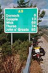
In days gone by, the A9 continued along the coast towards Wick and John O’Groats. That road is now known as the A99. Our route now turns inland along the old A895 to Thurso – mainland Britain's most northerly town, some 23 miles from Latheron. Much of this stretch is open moorland with little tree coverage. About 5 miles south of Thurso, the A882 from Wick joins our route. This is a TOTSO for A9 traffic.
The A9 continues north through Thurso to the small hamlet and large harbour of Scrabster. From here, it’s either turn round to go south again, or catch the ferry to Orkney. The third option is to take the A836 north coast road. The choice is yours. You’re about 110 miles north of Inverness here, 220 miles north of Perth and the nearest motorway (M90), and about 250 miles from the end of the M9 near Dunblane.
Original Author(s): M4 Man
Features of the A9
- The mix of dual carriageway and single carriageway on the Perth to Kessock bridge stretch of the A9, including the uncertain speed limits, "Furriners" forgetting to drive on the left and the very high "closing speeds".
- Average speed cameras - Inverness to Perth S2 only and Perth to Dunblane D2
- The unusually long "Clearway" signs - the distance leaving Inverness is given as 124 miles.
- The numbering system for the lay-bys, to assist emergency services when required.
- The snow gates, closing off the higher stretches when the weather turns wintry. There are also snow poles (for guidance) and snow fences.


