A97 (Northern Ireland)
Jump to navigation
Jump to search
| A97 | ||||
 | ||||
| From: | Hackballscross (H919114) | |||
| To: | Fane River (H873141) | |||
| Via: | Cullaville | |||
| Distance: | 3.4 miles (5.5 km) | |||
| Met: | T22, B30, T22 | |||
| Now part of: | A37 | |||
| Traditional Counties | ||||
| Route outline (key) | ||||
| ||||
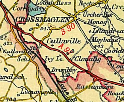
The number A97 is shown on 1940s Bartholomews Mapping as being on the present route of the duplicate A37 through Cullaville.
It has been speculated that the existence of the duplicate A37 may be an mis-transcription of the A97 number, which is otherwise unused in Northern Ireland. It should, however, be noted that there are no numbers similar to A97 in use in Northern Ireland, and no similar numbers appear to have been allocated historically.
This theory was debunked when the original road lists were found showing that the A37 existed here from the start. The A97 number, therefore, is simply a mapping error.
| A97 (Northern Ireland) | ||||
| ||||
| ||||
| ||||
|
