A9 Dulnain Bridge
Jump to navigation
Jump to search
| Dulnain Bridge | |||
| Location Map ( geo) | |||
 | |||
| |||
| From: | Aviemore | ||
| To: | Carrbridge | ||
| County | |||
| Inverness-shire | |||
| Highway Authority | |||
| Transport Scotland | |||
| Opening Date | |||
| 1981 | |||
| Additional Information | |||
| |||
| On road(s) | |||
| A9 | |||
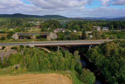
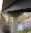
The A9 Dulnain Bridge is a large steel and concrete structure that spans the River Dulnain. From the north it is lead up to by a large embankment which runs parallel to the railway line. It has 2 concrete towers, similar in design to the Slochd bridge further north but much slender and smaller. The only way to get a good look at the bridge is to see it from the train and offers a good view of the structure.
Minor bridges
There are two smaller bridges to the north and south of the bridge but are very basic beam bridges which span a small stream to the north and an unclassified road to the south.
| A9 Dulnain Bridge | ||
|


