B6157
| B6157 | ||||||||||
| Location Map ( geo) | ||||||||||
| ||||||||||
| From: | Stanningley Bypass (SE208344) | |||||||||
| To: | Moortown (SE307390) | |||||||||
| Distance: | 7.9 miles (12.7 km) | |||||||||
| Meets: | A647, A6120, B6156, B6155, A657, A65, A660, B6159, A61 | |||||||||
| Former Number(s): | A647 | |||||||||
| Highway Authorities | ||||||||||
| Traditional Counties | ||||||||||
| Route outline (key) | ||||||||||
| ||||||||||
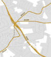
The B6157 is an urban B-road in Leeds.
The road starts at a signalised roundabout on the western edge of the Stanningley bypass, where it meets the A647 and A6120, and heads east along Bradford Road, the pre-bypass A647. It skirts the northern edge of Pudsey before reaching Stanningley itself.
The original line of the B6157 was along Leeds & Bradford Road to the east of the church. The original junction has been blocked off, however, so the B6157 continues a bit further along the ex-A647 before having to TOTSO left at traffic lights (the former A647 ahead is now unclassified), then TOTSO right at more traffic lights onto Leeds & Bradford Road. At this point the road is signposted to Harrogate.
The road heads clockwise in a big loop around Bramley. The first section is residential but then the road forms the edge of the urban area, with a park to the left. Eventually the road zigzags to cross over the Leeds & Liverpool Canal then quickly goes over the Leeds to Shipley railway line and the River Aire. The next turn to the right is a spur of the B6157 which provides access to/from the A65; that road is crossed at traffic lights soon afterwards although most movements, especially from the A65, are prohibited (the spur provides those that are missing).
The road continues east along Kirkstall Lane and passes Headingley railway station on the Leeds to Harrogate railway line. Shortly afterwards the road passes the cricket end of the Headingley Stadium before reaching traffic lights on the A660 in the centre of Headingley village.
There is a short multiplex north along the A660 before the B6157 regains its number by turning right at the next set of traffic lights. The road then TOTSOs left, with the road ahead (signposted York) being the B6159. The road zigzags to cross a stream before it TOTSOs left at a T-junction in Meanwood.
The road continues northeast along a fairly straight road. Although the road is largely residential there are some green areas on either side. After bearing right at the baptist church roundabout the road ends at the next roundabout on the A61, immediately to the south of its junction with the A6120 Outer Ring Road, which follows the same route as the B6157 but is not as interesting.


