Beattock Interchange
| Beattock Interchange | |||
| Location Map ( geo) | |||
 | |||
| The interchange's fork sign. | |||
| |||
| Location | |||
| Beattock | |||
| County | |||
| Dumfriesshire | |||
| Highway Authority | |||
| Transport Scotland | |||
| Junction Type | |||
| Parclo/Dumbbell Hybrid | |||
| Roads Joined | |||
| A74(M), A701, B7076 | |||
| Junctions related to the A701 | |||
| Junctions related to the B7076 | |||
The Beattock Interchange was the last junction of the Scottish section of the old A74 to be upgraded. Originally built as part of the A74 Beattock bypass in 1963, it was completely rebuilt in 1999 when the old dual carriageway was replaced. The old junction was of a similar Parclo-diamond layout to the current set up. The junction itself is a fairly standard dumbbell but with parclo slip roads for the northbound A74(M). This type particular layout is also found on the A2's interchange with the A223 down in Kent. It was the last motorway junction built in the 20th Century, if you consider the 20th century to have ended at the end of 1999, and not the end of 2000 as pedants do. The signage is also the only motorway fork sign to have a tourist i in its sign.
The junction itself is for the A701 for Dumfries and Moffat and the B7076 north to Elvanfoot and Crawford. As noted above it is a hybrid between a dumbbell and parclo type. The northern roundabout is a standard dumbbell, with the two sliproads, A701 to Moffat and under the bridge making a 4-arm roundabout. However to the south there are three roads and the sliproads to accommodate. This, and the proximity between the A701 and motorway to the south of the junction led to the sliproads being paired as with a parclo and approaching from the north west, alongside the northbound B7076, which is turned to arrive at the south west of the roundabout. To the south is the minor road into Beattock village, whilst the A701 to Dumfries departs to the east, quickly turning to run parallel to the motorway.
History
|
The T junction in 1962
|
The bypass junction shown in 1965
| |
The junction sits on the historic meeting point of the A74 and A701 from Moffat. Originally it was a simple T junction located just to the north of Beattock Bridge, but that was later changed when the A74 was dualled. At the point, a grade separated junction was installed with the A74 dual carriageway running from roughly the line of the modern B7076, and around the Beattock Bypass which is now the A701. The A701 passed underneath, with slip roads connecting the two routes on either side. On the south side of the A74, the A701 stopped with its sliproads, the old A74 route through Beattock becoming unclassiifed. The A701 then had another junction with the A74, after a short multiplex, to the south of the village.
Routes
| Route | To | Notes |
| The SOUTH, Carlisle | ||
| The NORTH, Glasgow, Edinburgh | ||
| Dumfries | ||
| Moffat, Selkirk (A708) | Scenic Route to Edinburgh | |
| Abington | ||
| Beattock | ||
| The NORTH, Glasgow, Edinburgh | ||
| The SOUTH, Carlisle |
Strip Maps
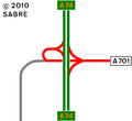
The layout as it was in 1980.
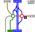
The layout as it is now.

_J15.PNG)
| Beattock Interchange | ||||||
| ||||||
|