Birchley Island
| Birchley Island | |||
| Location Map ( geo) | |||
 | |||
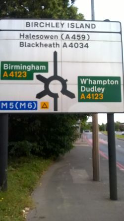
| Advance Direction Sign for the roundabout | |||
| |||
| Location | |||
| Langley | |||
| County | |||
| Worcestershire | |||
| Highway Authority | |||
| Sandwell | |||
| Junction Type | |||
| Roundabout | |||
| Roads Joined | |||
| A4034, A4123 | |||
| Junctions related to the A4123 | |||
Birchley Island is a large signalised roundabout at the intersection of the A4034 and A4123. It is located just to the south of the small settlement of Birchfield. The roundabout is of sufficient size to be home to an electricity substation and landscaping in the centre.
The roundabout has a spur linking it with Oldbury Interchange, for access to the M5 in both directions.
Various retail outlets and hotels have been added to the roundabout itself over the years, but while footpaths exist around the roundabout, none of the entries and exits have specific pedestrian phases, and some entrances are not signal controlled, making the environment hostile for pedestrians.
2010s Proposed Improvement
In 2014 and again in 2015, Sandwell Council consulted on improvements to the roundabout. The 2014 consultation rejected the following options:
- A - Minimum modifications: Widening the links between M5 junction 2 and Birchley Island to four lanes in each direction plus putting traffic lights on the Churchbridge and Wolverhampton Road approaches.
- D - Non-roundabout: Widening the links between M5 junction 2 and Birchley island to four lanes in each direction and the formation of a junction with traffic lights on the site of the current island.
Source: Sandwell Council (archive.org)
The 2015 consultation looked in detail at the two remaining options:
- B - Two-way "Hamburger" island - which would provide north and southbound hamburgerisation for the A4123 Wolverhampton Road
- D - One-way Dual Hamburger - which would provide a northbound cut-through for the A4123 Wolverhampton Road and a west to north cut through for traffic coming from the M5 and heading towards Oldbury.
Source: Sandwell Council (archive.org)
Option B was selected following this consultation. Source: Sandwell Council (archive.org)
Routes
| Route | To | Notes |
| Dudley, Wolverhampton | ||
| Birmingham, Harborne, Quinton | ||
| M5 (M6) | spur to M5 at Oldbury Interchange | |
| West Bromwich, Oldbury, Sandwell & Dudley station | ||
| Blackheath, Halesowen (A459) |
| Birchley Island | ||||
| ||||
|


