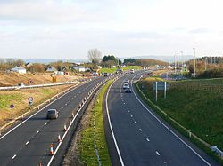
Blunsdon Bypass
| Blunsdon Bypass | |||
| Location Map ( geo) | |||
 | |||
| |||
| Scheme Type | |||
| Bypass | |||
| Construction Start Date | |||
| September 2006 | |||
| Opening Date | |||
| To Traffic: Northbound: 20th Jun 2008 Southbound: 16th Nov 2008 Official: May 2009 | |||
| Cost | |||
| £65.5 million | |||
| On road(s) | |||
| A419 | |||
The Blunsdon bypass is a dual carriageway avoiding Blunsdon in Wiltshire. Construction started in September 2006, and it opened to traffic in November 2008.
History
The A419 dual carriageway forms part of a vital link between the M4 and M5 motorways. The village of Blunsdon became a bottleneck on the route following upgrades of the surrounding routes. The route carried up to 50,000 vehicles per day through a traffic light junction and a roundabout. Villagers had campaigned for a bypass since the 1960s and, although it was planned in the 1990s, the Conservative government of the time dropped the scheme. A new scheme was put forward in 2002, passed through a public inquiry in 2005 and work on the £65.5 million scheme started on 18 September 2006, earlier than planned. The original plans included two grade separated junctions, however only one was built.
Construction
Whilst early works had started in September 2006, the main bulk of the construction work did not start until July 2007. A Little Chef restaurant and a BP petrol station had to be demolished to allow construction of the road. The traffic lights at the Lady Lane junction to the south of the village were turned off and removed in May 2008, following the diversion of Lady Lane onto a new bridge, however as a result of this new traffic lights were temporarily installed on a junction further to the south. Northbound traffic was diverted onto the bypass on 30 June 2008, to allow works on removing the roundabout to continue. The southbound carriageway was put into operation overnight between Saturday 15 and Sunday 16 November 2008
The old route through the village was reduced to a single carriageway, with a 30 mph speed limit. 84,000 trees and shrubs, and ¾ mile (1.2km) of hedgerows were planted along the line of the bypass. The official opening was marked by Graham Dalton (Highways Agency chief executive) planting the final tree.
Further Reading
BBC News
SABRE forum topics
- Blunsdon bypass--A419
- A419 - Blunsdon Bypass Work Starts...
- A417 Blunsdon Improvement now open northbound
Other
| Blunsdon Bypass | ||
|
|
This page was a candidate for Article of the Month October 2009 | ||


