Star.pngStar.pngStar.pngStar grey.pngStar grey.png

Branwell Lane

From Roader's Digest: The SABRE Wiki
Jump to navigation Jump to search
Branwell Lane
Location Map ( geo)
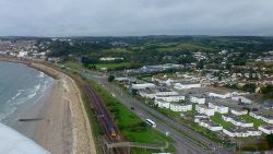
Road, rail and sea; from the air - Geograph - 3151543.jpg
Cameraicon.png View gallery (2)
Location
Penzance
County
Cornwall
Highway Authority
National Highways
Junction Type
Roundabout
Roads Joined
A30, B3311

Branwell Lane is the most eastern roundabout of the Penzance Primary Distributor Road, which acts as a bypass for the town. It is also the main access to the town to a large majority of traffic, and marks the last point at which the A30 is a Dual Carriageway. It experiences delays at peak times for traffic from both the Penzance PDR and the old route into the town due to its low capacity, being a small roundabout. It is also very busy in holiday season, as holiday traffic from Penzance, Newlyn and Mousehole from the B3311, West Cornwall on the A30 and commuter traffic from all directions meet here.

Originally built with the Penzance PDR in 1989, it was modified slightly in 1991 to account for the widened A30 to the east of the junction when that became a Dual Carriageway between Branwell Lane & Chy-An-Mor.

There is a segregated left turn from the A30 westbound to Penzance which merges with traffic from the roundabout, and from the A30 Penzance PDR to the unclassified road to the north of the junction where it gives way, which leads to the village of Gulval and the industrial park along Jelbert Way.


The name of the roundabout is referred to by the local authority in official documentation[1]; it is also referred to as Ponsandane Roundabout in the same document.


Routes

Route To Notes

A30

Redruth, Long Rock 1, Marazion 3, Helston (A394)

A30

Lands End, St Just, Newlyn, Heamoor, West Cornwall Hospital,

B3311

Penzance, Town Centre, Rail Station, Ferry, Gulval, Chysauster Former Route of A30

U6012

Heliport, Eastern Green Ind. Estate,


References


Branwell Lane
Related Pictures
View gallery (2)
Branwell Lane.JPGRoad, rail and sea; from the air - Geograph - 3151543.jpg
Other nearby junctions
Penzance
Junctions on the A30
London -
Exeter
Henlys Roundabout • Hatton Cross • Terminal 4 Roundabout • Clockhouse Roundabout • The Bull Dog • Crooked Billet • Runnymede Interchange • Runnymede Roundabout • Egham Hill Roundabout • Black Dam Roundabout • Hackwood Road Roundabout • Winchester Road Roundabout • Brighton Hill Roundabout • Kempshott Roundabout • Hatch Warren Roundabout • Dummer • Popham • Bullington Cross • Lopcombe Corner • St Marks Roundabout • Royal Chase Roundabout • Ivy Cross Roundabout • Bellmans Cross • Hospital Roundabout • Horsey Roundabout • Quicksilver Roundabout • Bunfield Hollow Roundabout • Bellmans Cross • Southay Cross • Devonshire House • Cheneys Farm Interchange • Langford Junction • Turks Head Junction • Pattesons Cross Junction • Iron Bridge Junction • Daisymount Junction • Country House Interchange • Pound Corner • Blackhorse Interchange • Sowton Interchange
Exeter -
Land's End
Pearce's Hill • Alphington • Fingle Glen • Woodleigh • Whiddon Down • Tongue End • Meldon • Sourton Cross • Stowford Cross • Liftondown • Tavistock Road Junction • Pennygillam • Trebursye • Kennards House • Two Bridges • Plusha • Fivelanes • Cannaframe • Bolventor • Temple Tor • Temple • Preeze Cross • Cardinham Downs • Callywith • Carminow Cross • Innis Downs • Victoria • Highgate Hill • Fraddon • Summercourt • Mitchell • Carland Cross • Boxheater • Chybucca • Chiverton Cross • Scorrier • Avers • Tolvaddon • Treswithian • Loggans Moor • St Erth Roundabout • Newtown Roundabout • Chy-An-Mor • Branwell Lane • Chyandour • Heamoor • Mount Misery

SABRE - The Society for All British and Irish Road Enthusiasts
Discuss - Digest - Discover - Help