Branxholm Bridge
Jump to navigation
Jump to search
| Branxholm Bridge | |||
| Location Map ( geo) | |||
 | |||
| |||
| From: | Hawick | ||
| To: | Langholm | ||
| Location | |||
| Branxholm | |||
| County | |||
| Roxburghshire | |||
| Highway Authority | |||
| Scottish Borders | |||
| Opening Date | |||
| 1932 | |||
| Additional Information | |||
| |||
| On road(s) | |||
| A7 | |||
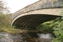
After leaving Hawick, the A7 heads south west up the valley of the River Teviot, and crosses the river twice, first at Branxholm(e) Bridge. The bridge was built in 1932, and spans the river with a single arch on the skew. In fact, the arch is quite a clever design, with a series of joined arch ribs stepped to create the angle of the skew.
The bridge carries an S2 road and pavements, with the parapets stepped in at either end across the arch, and with the arches skewed, the stone built parapets sit out of line to each other. Below the parapets, the spandrels and the arch ring itself are all of unrelieved concrete, with the only decoration to the faces being a slight projection in the stone of the parapet over the centre of the arch.
| Branxholm Bridge | ||||||||
| ||||||||
|

