Brown Lion Junction
Jump to navigation
Jump to search
| Brown Lion Junction | |||
| Location Map ( geo) | |||
 | |||
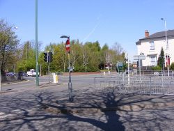
| Traffic lights at the junction in 2009 | |||
| |||
| Location | |||
| Pleck, Walsall | |||
| County | |||
| Staffordshire | |||
| Highway Authority | |||
| Walsall | |||
| Junction Type | |||
| Signalised crossroads | |||
| Roads Joined | |||
| A4038, A4148, C2000 | |||
| Junctions related to the A4038 | |||
Brown Lion Junction, located in the area of Pleck, southwest of Walsall town centre, is a simple light-controlled crossroads on the A4148 Walsall Ring Road where it meets the A4038 radial route towards the small Black Country town of Darlaston.
The junction was named after a pub that used to stand next to the site of the crossroads.
Routes
| Route | To | Notes |
| Ring Road, Wolverhampton, M6 North | ||
| Ring Road, Wednesbury, M6 South | ||
| Darlaston | ||
| Town Centre | ||
| Town Centre | ||
| Wolverhampton (A454) | ||
| Wednesbury |
| Brown Lion Junction | ||||
| ||||
|


