Star.pngStar grey.pngStar grey.pngStar grey.pngStar grey.png

C351 (Southampton)

From Roader's Digest: The SABRE Wiki
Jump to navigation Jump to search
C351
Location Map ( geo)
Cameraicon.png View gallery (12)
From:  Stoneham (city boundary) (SU437166)
To:  Townhill Park (city boundary) (SU454143)
Via:  Midanbury
Meets:  C351, A27, A35, C502, A3035, C68, C194
Highway Authorities

Southampton

Traditional Counties

Hampshire

Route outline (key)
C351 Stoneham (city boundary) - Swaythling
(A35) Swaythling
C351 Swaythling - Townhill Park (city boundary)
C351 (spur) Swaythling - Southampton Airport (city boundary)
C351 (spur) Midanbury - Bitterne Park

The C351 runs along Stoneham Lane, Langholm Road, Wide Lane, Wessex Lane, Woodmill Lane, Witts Hill, Mousehill Lane and Townhill Way in the city of Southampton.

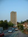


C351 (Southampton)
Junctions
Crossings
Miscellaneous
Related Pictures
View gallery (12)
Bus Stop on Wide Lane (C) Shaun Ferguson - Geograph - 947811.jpgHigh-rise student flats, Southampton (C) GaryReggae - Geograph - 26920.jpgWoodmill Lane, Southampton (C) GaryReggae - Geograph - 26903.jpgWoodmill Lane, Southampton (C) Alex McGregor - Geograph - 2382887.jpgLooking north on Stoneham Lane across... (C) Shazz - Geograph - 3357891.jpg
Other nearby roads
Southampton
NCN2 • NCN23 • NCN236 • NCN288 • A27 • A33 • A35 • A36 • A36(M) • A326 • A334 • A335 • A336 • A3024 • A3025 • A3035 • A3057 • A3067 • A3120 • B3033 • B3035 • B3036 • B3038 • B3039 • B3040 (Central Southampton) • B3040 (Southampton Common - Bitterne) • B3041 (Southampton) • B3042 (Hampshire) • B3053 • B3057 (Southampton) • B3380 (Southampton) • B3397 • C20 (Southampton) • C68 (Southampton) • C69 (Southampton) • C74 (Southampton) • C500 (Southampton) • C501 (Southampton) • C502 (Southampton) • C503 (Southampton) • C504 (Southampton) • C505 (Southampton) • C506 (Southampton) • E1 (Old System) • E05 • M3 • M27 • M270 • M271 • M272 • T7 (Britain) • T37 (Britain) • T39 (Britain) • Townhill Link Motorway
Southampton Airport
A335 • M27 • M272
Class III Roads Maintained by Hampshire, Portsmouth and Southampton Councils
Hampshire
Council
Portsmouth CouncilC423 • C440 • C441 • C443 • C446 • C448 • C450 • C452 • C454 • C456 • C457 • C459
Southampton CouncilC20 • C68 • C69 • C74 • C351 • C500 • C501 • C502 • C503 • C504 • C505 • C506


SABRE - The Society for All British and Irish Road Enthusiasts
Discuss - Digest - Discover - Help