Charleville Interchange
Jump to navigation
Jump to search
| Charleville Interchange Acomhal Bhaile an Ghleantúnaigh | |||
| Location Map ( geo) | |||
_-_Geograph_-_315638.jpg) | |||
| Charleville Interchange facing north | |||
| |||
| Location | |||
| Charleville | |||
| County | |||
| Louth | |||
| Highway Authority | |||
| Transport Infrastructure Ireland | |||
| Junction Type | |||
| Roundabout junction | |||
| Roads Joined | |||
| M1, N33 | |||
| Junctions related to the N33 | |||
The Charleville Interchange is Junction 14 of the M1 in County Louth. It is a standard roundabout junction connecting the motorway to the N33 just north of the River Dee and southeast of Stabannan. The L2226 provides an additional link, to the R132 at Sarsfield's Cross. The slip roads on the south side of the junction have relatively high bridges over the river. The junction was opened in 2001.
Routes
| Route | To | Notes |
| Droichead Átha DROGHEDA · Áth Cliath DUBLIN | ||
| Dún Dealgan DUNDALK · Béal Feirste BELFAST | ||
| Baile Átha Fhirdhia ARDEE | For N2 (A5) Doire DERRY | |
| Droim Chora DRUMCAR |
Grid reference
Pictures
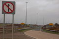
One of the junction's slip roads
_-_Geograph_-_315644.jpg)
Strip map
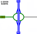
The current layout of the junction

| Charleville Interchange | ||
| ||
|

