Star.pngStar.pngStar grey.pngStar grey.pngStar grey.png

Chybucca Junction

From Roader's Digest: The SABRE Wiki
Jump to navigation Jump to search
Chybucca
Location Map ( geo)
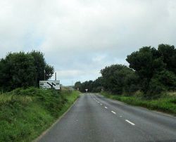
Cornwall B3284 Junction With A30 - Geograph - 3644066.jpg
Advance Direction sign for the junction in 2013
Cameraicon.png View gallery (1)
Location
Chybucca
County
Cornwall
Highway Authority
National Highways
Junction Type
T-Junction
Roads Joined
A30, B3284
Junctions related to the B3284

Chybucca is a staggered crossroads between the A30 and B3284, north west of Truro, Cornwall. The name of the junction appears on the Advance Direction Signs on the A30 approaches to the staggered junction.

It started out as two fork junctions between the two roads. At some point in the 1960s the A30 was subsequently upgraded to a Dual carriageway through the junction, allowing for overtaking and for refuges for turning traffic. This soon became quite dangerous at the junction is used by traffic trying get into Truro and avoid the A390 to the south and because it was one of few overtaking opportunities on the road. The A30 was narrowed to two wide lanes with longer refuges for turning traffic.

Chybucca is due to be the only intermediate junction on the latest A30 Dualling plans, and will provide west facing slips only to the new road at a dumbbell junction. It will also connect to the existing A30 as that will become an Local Access Road, much like some motorways have. During consultation, it was also the only site where an option was given on the routing of the road. The options were to the north or south of the house along the B3284 to the west.

Routes

Route To Notes

A30

Redruth, Perranport B3284

A30

Bodmin

B3284

Allet 1, Shortlanesend 2, Truro 4

B3284

Perranporth


Chybucca Junction
Related Pictures
View gallery (1)
Cornwall B3284 Junction With A30 - Geograph - 3644066.jpg
Junctions on the A30
London -
Exeter
Henlys Roundabout • Hatton Cross • Terminal 4 Roundabout • Clockhouse Roundabout • The Bull Dog • Crooked Billet • Runnymede Interchange • Runnymede Roundabout • Egham Hill Roundabout • Black Dam Roundabout • Hackwood Road Roundabout • Winchester Road Roundabout • Brighton Hill Roundabout • Kempshott Roundabout • Hatch Warren Roundabout • Dummer • Popham • Bullington Cross • Lopcombe Corner • St Marks Roundabout • Royal Chase Roundabout • Ivy Cross Roundabout • Bellmans Cross • Hospital Roundabout • Horsey Roundabout • Quicksilver Roundabout • Bunfield Hollow Roundabout • Bellmans Cross • Southay Cross • Devonshire House • Cheneys Farm Interchange • Langford Junction • Turks Head Junction • Pattesons Cross Junction • Iron Bridge Junction • Daisymount Junction • Country House Interchange • Pound Corner • Blackhorse Interchange • Sowton Interchange
Exeter -
Land's End
Pearce's Hill • Alphington • Fingle Glen • Woodleigh • Whiddon Down • Tongue End • Meldon • Sourton Cross • Stowford Cross • Liftondown • Tavistock Road Junction • Pennygillam • Trebursye • Kennards House • Two Bridges • Plusha • Fivelanes • Cannaframe • Bolventor • Temple Tor • Temple • Preeze Cross • Cardinham Downs • Callywith • Carminow Cross • Innis Downs • Victoria • Highgate Hill • Fraddon • Summercourt • Mitchell • Carland Cross • Boxheater • Chybucca • Chiverton Cross • Scorrier • Avers • Tolvaddon • Treswithian • Loggans Moor • St Erth Roundabout • Newtown Roundabout • Chy-An-Mor • Branwell Lane • Chyandour • Heamoor • Mount Misery

SABRE - The Society for All British and Irish Road Enthusiasts
Discuss - Digest - Discover - Help