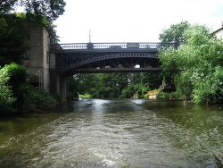
Cleveland Bridge (Bath)
| Cleveland Bridge | |||||
| Location Map ( geo) | |||||
 | |||||
| From: | Bathwick | ||||
| To: | Walcot | ||||
| Location | |||||
| Bath | |||||
| County | |||||
| Somerset | |||||
| Highway Authority | |||||
| Bath and North East Somerset | |||||
| Opening Date | |||||
| 1827 | |||||
| Additional Information | |||||
| |||||
| On road(s) | |||||
| A36 | |||||
Cleveland Bridge lies to the north east of Bath's City Centre, and connects the A36 in Bathwick to the A4 London Road. It was built by Goodridge in 1827 on the site of an ancient ferry crossing, and consists of six parallel cast iron arched spans carrying the road deck between stone abutments. The bridge is flanked at each end by two small lodges, in the Greek classical style that befits Bath. These limit the space on the deck to one lane each way, which can see traffic queued back from the Cleveland Place junction on the north bank. The bridge is a busy crossing, being the first untolled, usable crossing of the river since Stokeford Bridge several miles upstream.
The original contractor, Hazeldine, came from Shropshire - home of the Ironbridge - and had also worked with Thomas Telford. The bridge was 'reconstructed' in 1928, although this appears to have only been the deck, with the lodges remaining in situ, and therefore the carriageway width being unchanged. Further restoration work was carried out in 1992. However, the elegant iron parapet railings still carry a variety of plaques and inscriptions suggesting that they are the originals.
Today the bridge carries a primary route which is generally believed to be a spur of the A36. Whilst it is always labelled as such on maps, the signage is a little confusing, with traffic from the A36 being signed as though it was already on the A4. The bridge was not classified in 1922 at all, due to it still being a toll bridge. At that time, the A36 stayed on the south and east sides of Sydney Gardens. However, by the early 1930s the bridge had become part of an A road (unlabelled on 1930s OS 1:10560 sheets, but marked as the A36 on 1950s editions), and it appears that the north and west sides of Sydney Gardens were upgraded at the same time. At the north end of the bridge, the A36 spur quickly meets the A4 at the Cleveland Place junction.
| Cleveland Bridge (Bath) | ||||
| ||||
|


