County Laois
Jump to navigation
Jump to search
| County Laois Contae Laoise | |||
| Location Map ( geo) | |||
 | |||
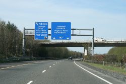
| The M7 (Port Laoise bypass) in County Laois | |||
| |||
| Terminal & Intermediate Destinations | |||
| Durrow • Port Laoise | |||
| Current Highway Authorities | |||
| Laois County Council | |||
| Borders | |||
| Carlow • Kildare • Kilkenny • Offaly • Tipperary | |||
County Laois is located in the southern midlands of Ireland. A landlocked county, it forms part of the province of Leinster and the Midlands Region of the Republic of Ireland.
From 1556 until 1922 County Laois was known as Queen's County. Other, now superseded, spellings of the name are Laoighis (Irish) and Leix (English).
Public highways in the county – other than national roads (including motorways), which are the responsibility of Transport Infrastructure Ireland – are managed by Laois County Council.
| Route | From | To | Length |
|
|---|---|---|---|---|
| M6 | Kinnegad | Galway | 129.2 km | View |
| M7 | Naas | Limerick | 195.6 km | View |
| M8 | Ballycuddahy | Dunkettle | 146.1 km | View |
| N7 | Dublin | Naas | 20 km | View |
| N8 | Dunkettle Interchange | Cork | 14 km | View |
| N9 | Grannagh | Waterford | .4 km | View |
| N77 | Kilkenny | Port Laoise | 48.7 km | View |
| N78 | Hennebry's Cross | Mullamast | 50 km | View |
| N80 | Clonminch | Ballynahallin | 114.7 km | View |
| R419 | Greatheath | Rathangan | 28.3 km | View |
| R420 | Killinure | Bawnoges | 54.7 km | View |
| R421 | Tullamore | Roscrea | 47.6 km | View |
| R422 | Cappakeel (M7 J15) | Coolagh Cross | 31.3 km | View |
| R423 | Portarlington | Mountrath | 25.6 km | View |
| R424 | Lea Cross | Monasterevin | 5.2 km | View |
| R425 | Rathbrennan | Abbeyleix | 16.9 km | View |
| R426 | Port Laoise | Castlecomer | 32 km | View |
| R427 | Cashel | Cloney | 21.9 km | View |
| R428 | Stradbally | Athy | 12.3 km | View |
| R429 | Ballickmoyler | Maganey Cross | 6.8 km | View |
| R430 | Carlow | Mountrath | 47.0 km | View |
| R431 | Crettyard | Molloys Cross | 4.7 km | View |
| R432 | Abbeyleix | Ballyragget | 17 km | View |
| R433 | Abbeyleix | Templemore | 37.2 km | View |
| R434 | Borris in Ossory | Durrow | 21 km | View |
| R435 | Borris in Ossory | Balief Cross | 29.0 km | View |
| R440 | Birr | Mountrath | 36.0 km | View |
| R445 | Naas | Cratloemoyle | 168.0 km | View |
| R639 | Durrow | Dunkettle | 134.0 km | View |
| R872 | Market Square | James Fintan Lalor Avenue | View | |
| R905 | Market Square | Eastern Relief Road | View | |
| R922 | Port Laoise | Togher | 2.1 km | View |
| R924 | Castlecomer Road Roundabout, Graigue | Bridge Street, Carlow | 1.6 km | View |
| T14 | Waterford | Tullamore | View | |
| L147 | Mountmellick | Abbeyleix | 31 km | View |
Key
Motorway
Primary Route
Non Primary Route
Former Motorway
Defunct Route
E Road
Future Motorway
Future Primary
Future Non Primary
Historical Route
Tourist Route
Roman Road
Unbuilt Motorway
Unbuilt Primary
Unbuilt Non Primary
National Cycle Network
Cycle Route
Eurovelo Cycle Route
Junctions
Main Article: Junctions in Laois
Bridges, Tunnels, and other Crossings
Main Article: Crossings in Laois


