County Roscommon
Jump to navigation
Jump to search
| County Roscommon Contae Ros Comáin | |||
| Location Map ( geo) | |||
 | |||
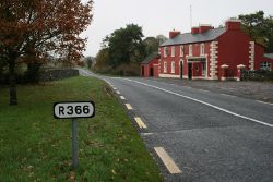
| On the R366 about 5 km from Roscommon town | |||
| |||
| Terminal & Intermediate Destinations | |||
| Roscommon | |||
| Other Important Destinations | |||
| Ballaghaderreen • Boyle | |||
| Current Highway Authorities | |||
| Roscommon County Council | |||
| Borders | |||
| Galway • Leitrim • Longford • Mayo • Offaly • Sligo • Westmeath | |||
County Roscommon is a landlocked county in northwest central Ireland. It forms a part of the province of Connacht and of the West Region of the Republic of Ireland. The upper River Shannon forms much of its eastern boundary.
Public highways in the county – other than national roads (including motorways), which are the responsibility of Transport Infrastructure Ireland – are managed by Roscommon County Council.
| Route | From | To | Length |
|
|---|---|---|---|---|
| M6 | Kinnegad | Galway | 129.2 km | View |
| N4 | Palmerstown | Sligo | 198.2 km | View |
| N5 | Aghadegnan (Longford bypass) | Westport | 132.1 km | View |
| N6 | Kinnegad | Galway | 148.0 km | View |
| N60 | Roscommon | Castlebar | 92.2 km | View |
| N61 | Boyle | Athlone | 73.7 km | View |
| N63 | Longford | Annagh Hill (M17 J19) | 87.5 km | View |
| N83 | Galway | Glentavraun | 73.4 km | View |
| R280 | Bundoran | Carrick-on-Shannon | 73.2 km | View |
| R284 | Tullynagracken South | Leitrim | 41.6 km | View |
| R285 | Ardcarn | Mountallen | 16.1 km | View |
| R293 | Ballynaboll | Ballyhaunis | 54.5 km | View |
| R294 | Boyle | Ballina | 62.7 km | View |
| R295 | Ballymote | Mocmoyne | 19.0 km | View |
| R325 | Glentavraun | Cloonarragh | 13.2 km | View |
| R326 | Loughglinn | Meelick | 3.6 km | View |
| R357 | Athleague | Blue Ball | 76.0 km | View |
| R361 | Carrownderry | Greatmeadow | 38.2 km | View |
| R362 | Knockaunbrack | Monksland | 59.2 km | View |
| R363 | Newbridge | Ballymullavill | 27.5 km | View |
| R366 | Roscommon | Aghagower | 10.7 km | View |
| R367 | Drumatemple | Tulsk | 16.7 km | View |
| R368 | Carrownalassan | Cortober | 34.6 km | View |
| R369 | Elphin | Gortnagoyne | 12.1 km | View |
| R370 | Sheevannan | Carrick on Shannon | 20.5 km | View |
| R371 | Tomisky | Ballyleague | 25.6 km | View |
| R377 | Castleplunket | Castlerea | 11.4 km | View |
| R446 | Kinnegad | Oranmore (E) | 141.3 km | View |
| R902 | Carrick Road, Boyle | Main Street, Boyle | View | |
| R914 | Galway Road, Athlone | Junction 12 of the N6 | 0.44 km | View |
| T54 | Carrick-on-Shannon | Bundoran | View | |
| T77 | Longford | Foxford | View |
Key
Motorway
Primary Route
Non Primary Route
Former Motorway
Defunct Route
E Road
Future Motorway
Future Primary
Future Non Primary
Historical Route
Tourist Route
Roman Road
Unbuilt Motorway
Unbuilt Primary
Unbuilt Non Primary
National Cycle Network
Cycle Route
Eurovelo Cycle Route
Junctions
Main Article: Junctions in Roscommon
Bridges, Tunnels, and other Crossings
Main Article: Crossings in Roscommon


