Star.pngStar.pngStar grey.pngStar grey.pngStar grey.png

Dartmouth Lower Ferry

From Roader's Digest: The SABRE Wiki
Jump to navigation Jump to search
Dartmouth Lower Ferry
Location Map ( geo)
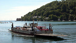
Dartmouth Lower Ferry - Geograph - 376318.jpg
Cameraicon.png View gallery (5)
From:  Dartmouth
To:  Kingswear
Distance:  0.6 km (0.4 miles)
County
Devon
Highway Authority
Devon
Opening Date
1700s
Toll
£3.20
On road(s)
B3205

The original ferry across the River Dart, still in use today as a minor crossing.

The ferry uses unpowered pontoons towed by hitched tug boats.

Links


Links


Dartmouth Lower Ferry
Related Pictures
View gallery (5)
Dartmouth Lower Ferry - Geograph - 376318.jpgDartmouth Lower Ferry - Coppermine - 19728.jpgCrossing the Dart on the Lower Ferry.JPGOnboard the Lower Dart Ferry.JPGDartmouth Lower Ferry ramp.JPG
Inland Ferry Crossings
Great BritainAust Ferry • Corran Ferry • Cowes Chain Ferry • Dartmouth Higher Ferry • Dartmouth Lower Ferry • Erskine Ferry • Gravesend to Tibury (P) • Humber Crossing • Instow to Appledore (P) • Itchen Chain Ferry • King Harry Ferry • Nigg • Renfrew to Yoker (P) • Sandbanks • Strome Ferry • Torpoint • Windermere • Woolwich
IrelandPassage East • Passage West • Strangford to Portaferry • Greencastle to Magilligan • Rathmullan to Buncrana • Tarbert to Killimer • Greencastle to Greenore
Other AreasIrish Sea • Inner Hebrides • Western Isles • Shetland • Orkney • North Sea • English Channel • Solent • Inland Crossings • Other Island Crossings


SABRE - The Society for All British and Irish Road Enthusiasts
Discuss - Digest - Discover - Help