Star.pngStar.pngStar.pngStar grey.pngStar grey.png

Disley and High Lane Bypass

From Roader's Digest: The SABRE Wiki
Jump to navigation Jump to search
Disley and High Lane Bypass
Location Map ( geo)
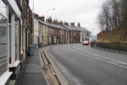
A6, Disley - Geograph - 2824980.jpg
The A6 passing through Disley
Cameraicon.png View gallery (1)
Scheme Type
Bypass
Cost
£97m (1996)
On road(s)
A6

The Disley and High Lane Bypass was a planned bypass on the A6 in Cheshire taking traffic out of the congested villages of Disley, High Lane, Newtown and Furness Vale. Four routes were considered to the north and south of the existing A6, labeled Brown, Blue, Purple and modified Brown. The preferred route was to the Brown route to the north (The A6 runs east - west at this point).

The bypass was first planned in the 1970s, however in the 1990s it was still considered a low priority[1], the plan was eventually cancelled on 26th November 1996 despite a preferred route being announced and £5m had already been spent on the project.

Preferred Route

The southern end of the bypass would have started at the terminal roundabout of the Chapel-en-le-Frith bypass before heading north to run alongside the railway as far as Newtown where it would run through the centre of the village. A roundabout with the A6015 would have been the only intermediate junction on the route. From there the route would have run west, passing to the north of Disley where it would have met the A6(M) at the A627 junction. The initial proposal was for a freeflow link to the A6(M) north but local opposition coupled with a newspaper article branding the junction a "22 lane monster" didn't help matters so the design was changed to make it join the junction at a roundabout. Stockport MBC on the other hand preferred a link to the Buxton Road Junction.

Map showing approximate representation of the preferred route shown in green, with the A6(M) and A555 shown in blue


Links

References


A6
Sections
Junctions
A14 J10 • Apollo Roundabout • Archers Roundabout • Ashwood Park • Aston Interchange (Derby) • Bamber Bridge Interchange • Bamber Bridge Junction • Bignells Corner • Blue Peter Island • Broughton Roundabout (Preston) • Brownedge Roundabout • Burton Road Roundabout (Kendal) • Chalton Interchange • Chequerbent Roundabout • Chowns Mill Roundabout • Cinnamon Hill Interchange • Clifton Cross • Clophill Roundabout • Cooper Turning • Cuerden Roundabout • Downing Street Junction • Elstow Interchange • Glen Gorse Roundabout • Golden Fleece Interchange • Hampson Green Roundabout • Hathern Turn • Hob Inn Roundabout • Icknield Way Roundabout • Keer Level Roundabout • Kegworth Interchange • Kemplay Bank Roundabout • Kidney Wood Roundabout • King Street Junction (Derby) • London Colney Roundabout • M42 J14 • M61 J4 • Nene Park Roundabout • New King Street • Orton Roundabout • Palm Court Island • Peahen Crossroads • Raynesway Island • Raynesway Park Junction • Red Hill Circle • Rising Sun (Hazel Grove) • Simpsons Corner • St Marys Roundabout (Luton) • Stockingstone • Telford Way Roundabout (Luton) • The Bell Roundabout • The Cock Pitt • The Hermitage Roundabout • Thulston Roundabout • Wanlip Roundabout
Services
Crossings
Roads
Places
Bakewell • Barnet • Bedford • Buxton • Carlisle • Chorley • Derby • Eccles • Hazel Grove • Kendal • Kettering • Lancaster • Leicester • Loughborough • Luton • Manchester • Market Harborough • Matlock • Penrith • Preston • Salford • Stockport
Miscellaneous
Related Pictures
View gallery (242)
A6, Low Hesket - Coppermine - 18360.JPGA6 - Coppermine - 10316.jpgB5021 Detail (Derby).JPGA6 Low Hesket.JPGIrthlingborough Viaduct crossing the River Nene - Geograph - 7333466.jpg

SABRE - The Society for All British and Irish Road Enthusiasts
Discuss - Digest - Discover - Help