Dunton services
Jump to navigation
Jump to search
| Dunton services | |||
| Location Map ( geo) | |||
| |||
| Location | |||
| Curdworth | |||
| County | |||
| Warwickshire | |||
| Opening Date | |||
| Never Built | |||
| On road(s) | |||
| M42 | |||
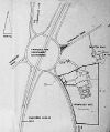
Dunton Services was one of four locations under consideration for a service area on the central section of the M42 through Warwickshire during the 1970s and early 1980s. It would have been located on the southeast corner of the roundabout at junction 9. The three alternative locations were Blackfirs between junction 6 and junction 7, Tamworth at junction 10 and Austrey.
In 1984 a planning application was made for a service area located on the southwest corner of the roundabout. This was refused as the land was protected for the future BNRR, later M6 Toll.
The site eventually chosen and built was Tamworth.
| Dunton services | ||||||
| ||||||
| ||||||
|

