File:A282 Strip Map 1980.PNG
Jump to navigation
Jump to search

Size of this preview: 266 × 599 pixels. Other resolution: 437 × 984 pixels.
Original file (437 × 984 pixels, file size: 41 KB, MIME type: image/png)
File history
Click on a date/time to view the file as it appeared at that time.
| Date/Time | Thumbnail | Dimensions | User | Comment | |
|---|---|---|---|---|---|
| current | 21:16, 20 April 2010 | | 437 × 984 (41 KB) | Abeaton (talk | contribs) | New version |
| 13:36, 26 January 2009 |  | 437 × 982 (37 KB) | Abeaton (talk | contribs) | ||
| 13:32, 26 January 2009 | No thumbnail | (37 KB) | Abeaton (talk | contribs) | ||
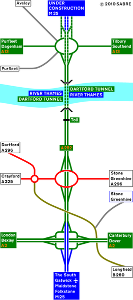
| 13:27, 26 January 2009 | No thumbnail | (36 KB) | Abeaton (talk | contribs) | Here is a 1980 strip map of the A282 |
File usage
The following page uses this file: