File:A47, Birmingham city-centre - Coppermine - 4350.jpg

From Roader's Digest: The SABRE Wiki
Jump to navigation Jump to search

A47,_Birmingham_city-centre_-_Coppermine_-_4350.jpg(768 × 576 pixels, file size: 62 KB, MIME type: image/jpeg)

Y topleft.gifY topright.gif
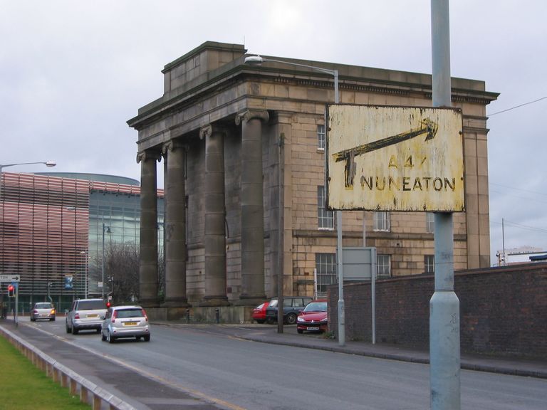
Description:A47, Birmingham city-centre

I spotted this rather rusty pre-warboys sign in Birmingham city-centre, on New Canal St. It directs motorists looking for the A47 down Curzon St. The A47 was re-routed, away from Curzon St, in the '60s along an elevated dual carriageway (Jennens Road). So by my reckoning, that makes this sign about 40 years out-of-date! This area is due for re-development soon, the roads are to be removed altogether to make way for a park and new library. So I don't hold any hope for this sign hanging around much longer.

Originally uploaded to Coppermine on Jan 02, 2006 by Steve-e-b
Location:52.48125, -1.88689
Road:A47, Birmingham
Date:2006
Photographer:Steve-e-b
Source:Coppermine

Map

Y btmleft.gifY btmright.gif

Galleries  | A47 | Birmingham | Category:Pictures without coords

File history

Click on a date/time to view the file as it appeared at that time.

Date/TimeThumbnailDimensionsUserComment
current12:32, 30 June 2010Thumbnail for version as of 12:32, 30 June 2010768 × 576 (62 KB)Bob@romiley1 (talk | contribs)'''A47, Birmingham city-centre''' I spotted this rather rusty pre-warboys sign in Birmingham city-centre, on New Canal St. It directs motorists looking for the A47 down Curzon St. The A47 was re-routed, away from Curzon St, in the '60s along an elevated

There are no pages that use this file.
SABRE - The Society for All British and Irish Road Enthusiasts
Discuss - Digest - Discover - Help