
No higher resolution available.
 | |  |
| | Description: | The A889 looking south just past its junction with the former A9 to Crubenmore. Complete with RCS, bends and snow gates! | | Location: | 56.9431483, -4.2385769 | | Road: | A889 | | Date: | 24 9 2010 | | Photographer: | Rileyrob | | Source: | |
|
|
| |
 | |  |
File history
Click on a date/time to view the file as it appeared at that time.
| Date/Time | Thumbnail | Dimensions | User | Comment |
|---|
| current | 16:36, 25 October 2010 | 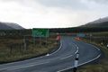 | 640 × 427 (93 KB) | Rileyrob (talk | contribs) | The A889 looking south just past its junction with the former A9 to Crubenmore. Complete with RCS, bends and snow gates! |
File usage
The following page uses this file:
This file contains additional information, probably added from the digital camera or scanner used to create or digitise it.
If the file has been modified from its original state, some details may not fully reflect the modified file.
