File:Amersham classified roads.GIF
Jump to navigation
Jump to search

No higher resolution available.
Amersham_classified_roads.GIF (800 × 200 pixels, file size: 8 KB, MIME type: image/gif)
| |||||||||||||||||||||||||
|
Galleries | B473 | B472 (Beaconsfield - Amersham) | A4090 (Amersham) | Amersham | Other Mapping | A413 | A404 | A416 | A4154 | ||
File history
Click on a date/time to view the file as it appeared at that time.
| Date/Time | Thumbnail | Dimensions | User | Comment | |
|---|---|---|---|---|---|
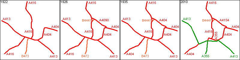
| current | 16:42, 26 April 2012 | 800 × 200 (8 KB) | Si404 (talk | contribs) | The evolution of nationally classified roads in Amersham, beginning with 1922, through the addition of more roads and renumbering by 1926 and then the changes to numbering in [[1935 Road | |
| 16:37, 26 April 2012 | 800 × 200 (8 KB) | Si404 (talk | contribs) | The evolution of nationally classified roads in Amersham, beginning with 1922, then with the addition of more roads in 1924 and the 1920s South Buckinghamshire Renumbering, then the changes to numbering in [[1935 Road numberin | ||
| 16:48, 16 April 2010 | 800 × 200 (8 KB) | Sabristo simon (talk | contribs) | The evolution of nationally classified roads in Amersham, beginning with 1922, through the addition of more roads by 1932 and then the changes to numbering in 1935 an |
File usage
The following 9 pages use this file: