 | |  |
| | Description: | Melrose by-pass, with the remains of Melrose Station giving a clue as to what mode of transport this corridor used to be used for | | Location: | 55.5965651, -2.7209079 | | Road: | A6091 | | Date: | 27 7 2011 | | Photographer: | Stevie D | | Source: | |
|
|
| |
 | |  |
File history
Click on a date/time to view the file as it appeared at that time.
| Date/Time | Thumbnail | Dimensions | User | Comment |
|---|
| current | 23:24, 17 August 2011 | 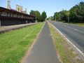 | 3,296 × 2,472 (1.86 MB) | Stevie d (talk | contribs) | Melrose by-pass, with the remains of Melrose Station giving a clue as to what mode of transport this corridor used to be used for |
File usage
The following page uses this file:
This file contains additional information, probably added from the digital camera or scanner used to create or digitise it.
If the file has been modified from its original state, some details may not fully reflect the modified file.

