File:Darenth Interchange 1991.png
Jump to navigation
Jump to search

No higher resolution available.
Darenth_Interchange_1991.png (340 × 272 pixels, file size: 11 KB, MIME type: image/png)
| |||||||||||||||||||||||||
|
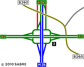
Galleries | M25 | A2 | A282 | Darenth Interchange | Strip Maps | ||
File history
Click on a date/time to view the file as it appeared at that time.
| Date/Time | Thumbnail | Dimensions | User | Comment | |
|---|---|---|---|---|---|
| current | 13:17, 23 January 2010 | | 340 × 272 (11 KB) | Abeaton (talk | contribs) | Fix |
| 13:16, 23 January 2010 |  | 340 × 272 (11 KB) | Abeaton (talk | contribs) | Tidy up of northbound slip road. | |
| 10:50, 22 January 2010 |  | 340 × 272 (11 KB) | Abeaton (talk | contribs) | {{Information |description = Darenth Interchange as it was in 1991 |road = M25 }} |
File usage
The following 2 pages use this file: