File:Junction of the Mountain Road and... (C) Neil Owen - Geograph - 1926929.jpg

From Roader's Digest: The SABRE Wiki
Jump to navigation Jump to search

Junction_of_the_Mountain_Road_and..._(C)_Neil_Owen_-_Geograph_-_1926929.jpg(640 × 473 pixels, file size: 54 KB, MIME type: image/jpeg)

Y topleft.gifY topright.gif
Description:
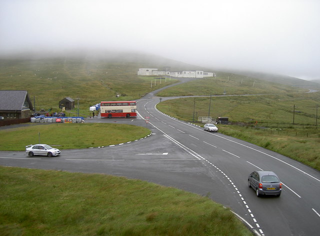
Junction of the Mountain Road and... (C) Neil Owen
Taken from the footbridge, here we can see the main road, the tram station on the left, the motorcycle museum on the hill (white buildings), and the 'Cloak of Mannanan' enshrouding the peak of Snae Fell. Incidentally, the TT riders follow the road off the mountain towards the footbridge and is one of the most iconic spots to spectate.
Location:54.251120, -4.463819
Road:A18 (Isle of Man), TT Circuit , A14 (Isle of Man)
Date:17 07 2008
Photographer:Neil Owen and licensed for reuse under this Creative Commons Licence
Source:Geograph

Map

Y btmleft.gifY btmright.gif

Galleries  | A18 (Isle of Man) | TT Circuit | A14 (Isle of Man) | Bungalow

File history

Click on a date/time to view the file as it appeared at that time.

Date/TimeThumbnailDimensionsUserComment
current21:29, 17 June 2013Thumbnail for version as of 21:29, 17 June 2013640 × 473 (54 KB)Si404 (talk | contribs)'''Junction of the Mountain Road and... (C) Neil Owen '''<br/>Taken from the footbridge, here we can see the main road, the tram station on the left, the motorcycle museum on the hill (white buildings), and the 'Cloak of Mannanan' enshrouding the peak ...

The following 3 pages use this file:

SABRE - The Society for All British and Irish Road Enthusiasts
Discuss - Digest - Discover - Help