File:Vale of Rheidol Railway (C) John Lucas - Geograph - 659211.jpg

From Roader's Digest: The SABRE Wiki
Jump to navigation Jump to search

Vale_of_Rheidol_Railway_(C)_John_Lucas_-_Geograph_-_659211.jpg(640 × 480 pixels, file size: 65 KB, MIME type: image/jpeg)

Y topleft.gifY topright.gif
Description:
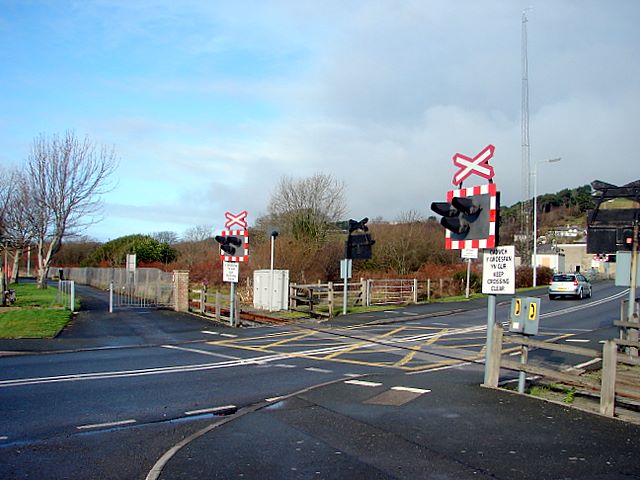
Vale of Rheidol Railway (C) John Lucas
The level crossing at Llanbadarn Fawr. Controlled by lights without barriers, all trains have to stop to allow a crew member to operate the lights by means of a plunger.
Location:52.405779, -4.060922
Road:A4120
Date:15 01 2008
Photographer:John Lucas and licensed for reuse under this Creative Commons Licence
Source:Geograph

Map

Y btmleft.gifY btmright.gif

Galleries  | A4120 | Level Crossing | Cardiganshire | Aberystwyth

File history

Click on a date/time to view the file as it appeared at that time.

Date/TimeThumbnailDimensionsUserComment
current11:30, 30 October 2013Thumbnail for version as of 11:30, 30 October 2013640 × 480 (65 KB)Glen (talk | contribs)'''Vale of Rheidol Railway (C) John Lucas '''<br/>The level crossing at Llanbadarn Fawr. Controlled by lights without barriers, all trains have to stop to allow a crew member to operate the lights by means of a plunger.

Metadata

SABRE - The Society for All British and Irish Road Enthusiasts
Discuss - Digest - Discover - Help