Gallery:A648 (Kegworth - Nottingham)
This page includes a scan of a non-free copyrighted map, and the copyright for it is most likely held by the company or person that produced the map. It is believed that the use of a limited number of web-resolution scans qualifies as fair use under United States copyright law, where this web page is hosted, as such display does not significantly impede the right of the copyright holder to sell the copyrighted material, is not being used to generate profit in this context, and presents information that cannot be exhibited otherwise.
If the copyright holder considers this is an infringement of their rights, please contact the Site Management Team to discuss further steps.
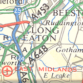
I had assumed that the A648 ended at the A52 Clifton Bridge, but a 1976 map tells a different story. The A648 carries on, on what is now the B679 to end at the A60/A606 junction.
Also note the Ring Road is here as the A614 and before the A6019 is here before the A453 took its place.
Originally uploaded to Coppermine on Sep 30, 2005 by Col
This page includes a scan of a non-free copyrighted map, and the copyright for it is most likely held by the company or person that produced the map. It is believed that the use of a limited number of web-resolution scans qualifies as fair use under United States copyright law, where this web page is hosted, as such display does not significantly impede the right of the copyright holder to sell the copyrighted material, is not being used to generate profit in this context, and presents information that cannot be exhibited otherwise.
If the copyright holder considers this is an infringement of their rights, please contact the Site Management Team to discuss further steps.
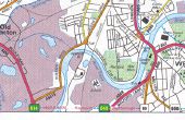
Before the A453 was routed along Queen's Drive in 1978, Queen's Drive at this stage was the A6019. The A648 at that stage was what we now call the A453.
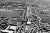
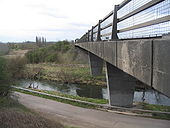
The Roundabout, as can be seen, was built first.The road alongside the river runs from Red Hill marina (right) to Ratcliffe on Soar (left)
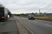
The A453, east of the M1, is the major route between Nottingham, the M1 and Nottingham East Midlands Airport. It is one of the most congested roads in the country, carrying up to 30000 vehicles a day. Work on long-awaited major improvements to widen a seven mile stretch of the A453 between M1 Junction 24 and the A52 Nottingham Ring Road started in January 2013. The scheme is scheduled to be completed in summer 2015 and is planned to reduce congestion and make the route safer.
A new roundabout at Mill Hill will be sited to the west of the Nottingham City Council and Nottinghamshire County Council boundary, and will provide a connection to the existing A453, Fox Covert Lane and Clifton Lane via a new link road. This road will provide a link to the new Nottingham Express Transit (NET) Park and Ride site, transporting people directly from Clifton into the centre of Nottingham by tram.
<a title='http://transport.nottinghamcity.gov.uk/Projects/A453.aspx' rel='nofollow' href='http://transport.nottinghamcity.gov.uk/Projects/A453.aspx'>Link</a><img style='padding-left:2px;' alt='External link' title='External link - shift click to open in new window' src='http://s1.geograph.org.uk/img/external.png' width='10' height='10'/> Nottingham City Council
<a title='http://assets.highways.gov.uk/roads/road-projects/a453-widening-m1-junction-24-to-a52-nottingham/A453_Widening_Plan.pdf' rel='nofollow' href='http://assets.highways.gov.uk/roads/road-projects/a453-widening-m1-junction-24-to-a52-nottingham/A453_Widening_Plan.pdf'>Link</a><img style='padding-left:2px;' alt='External link' title='External link - shift click to open in new window' src='http://s1.geograph.org.uk/img/external.png' width='10' height='10'/> the map of route
