Gallery:M53

Clearly visible blue patch over the 1 of M531 at J8 on the now M53
Originally uploaded to Coppermine by GRC_697


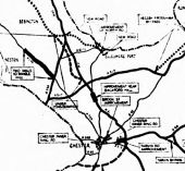
Note the M531 and the long M57 spur - extending to the A57 (shown as built, aswell!)
Originally uploaded to Coppermine on Jan 01, 2006 by DavidBrown
This page includes a scan of a non-free copyrighted map, and the copyright for it is most likely held by the company or person that produced the map. It is believed that the use of a limited number of web-resolution scans qualifies as fair use under United States copyright law, where this web page is hosted, as such display does not significantly impede the right of the copyright holder to sell the copyrighted material, is not being used to generate profit in this context, and presents information that cannot be exhibited otherwise.
If the copyright holder considers this is an infringement of their rights, please contact the Site Management Team to discuss further steps.


Showing when the Ellesmere Port bypass became the M531 - not when it became M53 later on!
OP Chris H
Originally uploaded to Coppermine on Apr 14, 2005 by M4Simon
This page includes a scan of a non-free copyrighted map, and the copyright for it is most likely held by the company or person that produced the map. It is believed that the use of a limited number of web-resolution scans qualifies as fair use under United States copyright law, where this web page is hosted, as such display does not significantly impede the right of the copyright holder to sell the copyrighted material, is not being used to generate profit in this context, and presents information that cannot be exhibited otherwise.
If the copyright holder considers this is an infringement of their rights, please contact the Site Management Team to discuss further steps.

Mapping error showing one of the tunnels as motorway Originally uploaded to Coppermine on Apr 14, 2005 by Jonathan B4027
This page includes a scan of a non-free copyrighted map, and the copyright for it is most likely held by the company or person that produced the map. It is believed that the use of a limited number of web-resolution scans qualifies as fair use under United States copyright law, where this web page is hosted, as such display does not significantly impede the right of the copyright holder to sell the copyrighted material, is not being used to generate profit in this context, and presents information that cannot be exhibited otherwise.
If the copyright holder considers this is an infringement of their rights, please contact the Site Management Team to discuss further steps.

Possible southern route of M53 at time of site investigation
Originally uploaded to Coppermine on Jun 22, 2007 by RichardA35
Possible route of M53 at time of site investigations
Originally uploaded to Coppermine on Jun 22, 2007 by RichardA35
Northern terminus of M53
Originally uploaded to Coppermine on Jun 09, 2005 by MSAJohnny


Key: Solid line = roads under construction or complete Dashed line = in planning pool Black dotted line = future government scheme
White dotted line = future County schemes
