Star.pngStar.pngStar.pngStar grey.pngStar grey.png

Groes Interchange

From Roader's Digest: The SABRE Wiki
Jump to navigation Jump to search
Groes Interchange
Cyfnewidfa'r Groes
Location Map ( geo)
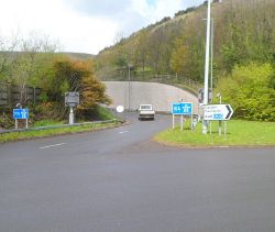
The only slip road at M4 motorway junction 39, Margam, Port Talbot - Geograph - 2954313.jpg
Cameraicon.png View gallery (2)
Location
Margam (SE)
County
Glamorgan
Highway Authority
Welsh Government
Junction Type
On-slip
Roads Joined
M4, A48

Groes Interchange, located about 2.5 miles south-east of Port Talbot town centre, is junction 39 of the M4 motorway. As far as motorway traffic is concerned, the interchange amounts to a single slip road providing access from the A48 to the westbound carriageway of the M4. All other movements between the motorway and the A48 are dealt with at the Margam Interchange (junction 38) which lies two thirds of a mile further south-eastwards.

History

The roundabout at this site, as first built in the 1960s, originally formed the south-eastern terminus of the A48(M) (Port Talbot Bypass) and its junction with the A48. When the motorway was extended eastwards a decade later (the whole route becoming part of the M4), it followed a route close to the north-eastern, landward side of the A48. The selection of this alignment entailed the complete destruction of the village of Groes: its 22 homes and school were demolished and its landmark octagonal chapel was dismantled and rebuilt on a new site half a mile to the north-west, so that the name "Groes" now survives only as that of a motorway junction.

A quarter of a mile or so of the westbound carriageway of the former A48(M) between the roundabout and the present M4 was retained as a west-facing slip road; as noted above, other traffic movements between the motorway and the A48 are handled at the nearby junction 38.

Routes

Route To Notes

M4

Abertawe / Swansea

A48

Port Talbot No access from M4

A48

Caerdydd / Cardiff No access from M4


Groes Interchange
Related Pictures
View gallery (2)
The only slip road at M4 motorway junction 39, Margam, Port Talbot - Geograph - 2954313.jpgM4PortTalbotEastTerminus.jpg
Junctions on the M4
Main RouteChiswick • 2 Brentford • 3 Cranford Parkway • 4 Heathrow • 4B Thorney • 5 Langley • 6 Tuns Lane • 7 Huntercombe • 8/9 Holyport • 10 Winnersh • 11 Three Mile Cross • 12 Theale • 13 Chieveley • 14 Wickham • 15 Plough Hill • 16 Spittleborough • 17 Stanton St Quintin • 18 Tormarton • 19 Hambrook • 20 Almondsbury • 21 Awkley • 22 Pilning • 23 Rogiet • 23A Magor • 24 Coldra • 25 Caerleon • 25A Grove Park • 26 Malpas • 27 High Cross • 28 Tredegar Park • 29 Castleton • 30 Pentwyn • 31 Junction 31 • 32 Coryton • 33 Cardiff West • 34 Miskin • 35 Pencoed • 36 Sarn • 37 Pyle • 38 Margam • 39 Groes • 40 Taibach • 41 Pentyla • 42 Earlswood • 43 Llandarcy • 44 Lon-Las • 45 Ynysforgan • 46 Llangyfelach • 47 Penllergaer • 48 Hendy • 49 Pont Abraham
Heathrow SpurCherry Lane • 4 Heathrow • 4A Concord
Former RoutesBray • 9A Cox Green • 9B The Thicket // 19 Hambrook • 19A Frenchay // 20 Almondsbury • 21 Aust • 22 Newhouse • 23 Magor // 28  Tredegar Park • 29 St Mellons
Defunct Newport
Bypass Proposal
23 Rogiet • 25 Glan Llyn • 27 Dock Way • 29 Castleton
Junctions on the A48
Highnam Roundabout • Highbeech Roundabout • Parkwall Roundabout • Coldra • Beatty Road Roundabout • Hartridge Farm Road Roundabout • Balfe Road Roundabout • Queensway Meadows Roundabout • Nash Road Roundabout • Church Street Roundabout • Maesglas East • Maesglas West • Ebbw Bridge Roundabout • Tredegar Park • St Mellons • Culverhouse Cross • Sycamore Cross • Waterton Cross • Margam • Groes • Earlswood • Lon-Las • Llangyfelach • Penllergaer • Pont Abraham • Meadows Bridge • Cross Hands • Pensarn

SABRE - The Society for All British and Irish Road Enthusiasts
Discuss - Digest - Discover - Help