Star.pngStar.pngStar grey.pngStar grey.pngStar grey.png

Hammondstown Interchange

From Roader's Digest: The SABRE Wiki
Jump to navigation Jump to search
Hammondstown Interchange
Location Map ( geo)
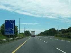
The south-bound carriageway of the M1 at Shamrock Hill - Geograph - 3522188.jpg
Fork sign heading southbound approaching the junction
Cameraicon.png View gallery (3)
Location
Dunleer
County
Louth
Highway Authority
Transport Infrastructure Ireland
Junction Type
Diamond
Roads Joined
M1, R169

Hammondstown Interchange is junction 12 of the M1.

Routes

Route To Notes

M1

Beal Feirste/BELFAST, Dun Dealgan/DUNDALK 23

M1

Áth Cliath/DUBLIN, Droichead Átha/DROGHEDA 14

R169

Collann/COLLON

R169

Dun Leire/DUNLEER


Hammondstown Interchange
Related Pictures
View gallery (3)
The R169 at Junction 12 of the M1 - Geograph - 3763545.jpgThe south-bound carriageway of the M1 at Shamrock Hill - Geograph - 3522188.jpg20161228-1552 - M1 southbound looking towards J12 - 53.831099N 6.4110235W.jpg
Junctions on the M1 and N1
Turnapin • 2 Cloghran • Airport • 3 Drinan • 4 Lissenhall • 5 Rowans Road • 6 Balbriggan • 7 Gormanston • 8 & 9 Drogheda South • 10 Drogheda North • 11 Monasterboice • 12 Hammondstown • 13 Mooremount • 14  Charleville • 15 Drumleck • 16 Southern Link • 17 Castleblayney Road • 18 Ballymascanlan (Ballymascanlan Roundabout • Faughart Roundabout • Major's Hollow) • 19 Feede Cross • 20 Flurrybridge

SABRE - The Society for All British and Irish Road Enthusiasts
Discuss - Digest - Discover - Help