Star.pngStar.pngStar grey.pngStar grey.pngStar grey.png

High Level Bridge

From Roader's Digest: The SABRE Wiki
Jump to navigation Jump to search
High Level Bridge
Location Map ( geo)
High-level-br2.jpg
Cameraicon.png View gallery (4)
From:  Newcastle
To:  Gateshead
Location
Newcastle-upon-Tyne
County
Northumberland • Durham
Highway Authority
Newcastle upon Tyne • Gateshead
Opening Date
1849
Additional Information
Bridge Type:  Truss Bridge
On road(s)
B1307

The High Level Bridge across the Tyne was the first bridge across the Tyne between Newcastle and Gateshead, and as a result it was the first to overcome a number of major problems. With the Tyne being 150 metres wide and a fast-flowing channel with layers of silt over bedrock any bridge requiring piers in the channel was going to be a challenging project. It is perhaps little wonder then that the bridge was constructed as a double deck road and rail structure.

The original route of the A1 ran along the bridge until moved to the Tyne Bridge in 1928.

Structure

The High Level Bridge

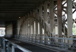
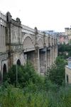
The bridge consists of six 38-metre spans across the Tyne, each of which comprises four wrought-iron arched trusses supporting the rail deck. The road deck is then effectively suspended from the rail deck on steel suspension hangers, the number of which were increased in the 1920s to allow trams to cross the bridge. Each span is supported by paired stone piers rising from massive cutwaters in the river. These, in turn, are protected by timber pontoons to prevent strikes from passing ships, and rest on massive timber piles driven into the river bed.

Whilst the road deck looks narrow today, before the refurbishment it was a full S2 roadway running between the piers. The pedestrian walkways are located on the outside of the road deck, running through the trusses with the arch cross-members terminating about seven feet above the pavement level. The road continues straight at either end of the bridge, while the railway lines curve away to east and west at the Gateshead end, and to the west into Newcastle Station. There is also a short projection of the rail deck over the road at the Newcastle end, perhaps suggesting that there was once a plan to provide an eastward link here too, although the medieval castle keep stands in the way - the rest of the castle is largely lost under railway viaducts and roads.

Refurbishment

Between 2000 and 2008 the bridge underwent a major refurbishment. This involved the removal, stress testing and reinstatement of a number of beams, the installation of crash barriers to prevent vehicles damaging the piers and the implementation of vehicle restrictions. These mean that the bridge is now one-way, southbound and only open to local buses and taxis, with the 3-tonne weight limit seeming a little strange when fully laden buses still cross in convoy.



High Level Bridge
Related Pictures
View gallery (4)
High-level-br1.jpgHigh-level-br2.jpgTyne-brs.jpgNewcastle High Level Bridge.jpg
Other nearby roads
Newcastle upon Tyne
A1 • A1(M) • A1(M)/Newcastle Central Motorway East • A1/Sandbox • A69 • A108 (Seaham - Seaton Burn) • A167 • A167(M) • A184 • A186 • A187 • A188 • A189 • A191 • A193 • A695 • A695(M) • A696 • A696(M) • A1056 (Northumberland) • A1057 (Newcastle upon Tyne) • A1058 • A1058(M) • A1059 (Newcastle upon Tyne) • A1060 (Newcastle upon Tyne) • A6082 • A6085 • A6086 (Newcastle-upon-Tyne) • A6115 (Tyneside) • A6125 • A6126 • A6127 • A6127(M) • B1296 • B1304 (Newcastle) • B1305 • B1305 (Quayside, Newcastle) • B1306 (Newcastle) • B1307 • B1308 (Newcastle) • B1309 • B1309 (Jesmond) • B1310 • B1311 • B1311 (Byker) • B1312 • B1312 (Byker) • B1313 • B1314 • B1318 • B1600 • B6323 • B6324 • B6325 (Newcastle) • B6326 (Newcastle) • B6327 • B6328 • B6329 • B6330 • B6331 • B6332 • B6333 • B6334 • B6335 • B6336 • B6337 • B6338 • B6339 • B6340 (Gosforth) • B6431 (Newcastle upon Tyne) • B6440 • B6528 • B6534 • C101 (Newcastle upon Tyne) • C103 (Newcastle upon Tyne) • C104 (Newcastle upon Tyne) • C105 (Newcastle upon Tyne) • C106 (Newcastle upon Tyne) • C107 (Newcastle upon Tyne) • C108 (Newcastle upon Tyne) • C109 (Newcastle upon Tyne) • C110 (Newcastle upon Tyne) • C111 (Newcastle upon Tyne) • C112 (Newcastle upon Tyne) • C113 (Newcastle upon Tyne) • C114 (Newcastle upon Tyne) • C115 (Newcastle upon Tyne) • Central Motorway East Bypass • Central Motorway West • E15 • E18 • E31 (via Newcastle) • E110 (Old System) • East-West Underground Motorway • Friars Goose Crossing • T1 (Britain) • T25 (Britain) • T86 (Britain)
Gateshead
A1(M) • A69 • A167 • A184 • A185 • A185(M) • A189 • A194(M) • A195 • A613 (Gateshead) • A692 • A1114 (Gateshead) • A6081 • A6082 • A6083 • A6084 • A6115 (Tyneside) • A6125 • A6126 • A6127 • A6171 • B601 • B1288 • B1295 (Gateshead) • B1296 • B1296 (Gateshead - Heworth) • B1307 • B1426 • B6317 • Central Motorway East Bypass • E15 • E31 (via Newcastle) • Friars Goose Crossing • M100 • T1 (Britain) • T25 (Britain)
Crossings of the River Tyne, Derwent and other Tributaries
Tyne BridgesHexham Bypass Bridge • Hexham Bridge • Corbridge Bridge • Styford Bridge • Bywell Bridge • Blaydon Bridge • Scotswood Bridge • New Redheugh Bridge • High Level Bridge • Swing Bridge • Tyne Bridge • Friars Goose Crossing • Tyne Tunnel
River North TyneBellingham Bridge • Chollerford Bridge
River South TyneAlston Bridge • Haltwhistle Bypass Bridge 2 • Haltwhistle Bypass Bridge 1 • Haydon Bypass Bridge • Haydon Bridge
Derwent BridgesBlanchland Bridge • Derwent Bridge (Edmundbyers) • Allensford Bridge • Shotley Bridge • Ebchester Bridge • Lintzford Bridge • Derwent Bridge (Durham) • New Derwent Bridge •  • A1 Blaydon Bridge • Metroland Bridge

SABRE - The Society for All British and Irish Road Enthusiasts
Discuss - Digest - Discover - Help